Home > Architecture > Styles > Berlin Architecture
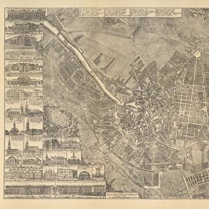
Map of Berlin showing buildings of interest, 1773 (engraving)
")
![]()
Wall Art and Photo Gifts from Fine Art Finder
Map of Berlin showing buildings of interest, 1773 (engraving)
AGD355560 Map of Berlin showing buildings of interest, 1773 (engraving) by Schleuen, Johann David (fl.1740-74); 57.4x84.2 cm; Private Collection; (add.info.: Die Koenigliche Residenz Berlin, so wie selbige seit Ao. 1734 unter voriger Koenigl. Regierung ansehnlich erweitet, ... bis Ao. 1773 veraendert, verbessert und mit vielen praechtigen Gebaueden vermehret worden; Royal Residence, showing changes made between 1734-73; ); German, out of copyright
Media ID 22678010
© Bridgeman Images
Alterations Berlin Landmarks Town Hall Town Planning
FEATURES IN THESE COLLECTIONS
> Architecture
> Churches
> Architecture
> Country
> Germany
> Architecture
> Related Images
> Architecture
> Styles
> Berlin Architecture
> Fine Art Finder
> Artists
> Johann David Schleuen
> Fine Art Finder
> Maps (celestial & Terrestrial)
> Historic
> Monuments and landmarks
> Monuments and memorials
> Historic
> Monuments and landmarks
> Maps and Charts
> Early Maps
EDITORS COMMENTS
This print showcases a meticulously detailed "Map of Berlin showing buildings of interest" from the year 1773. Created by Johann David Schleuen, a skilled engraver during the period, this historical piece measures an impressive 57.4x84.2 cm and is part of a private collection. The map provides a fascinating glimpse into the evolution of Berlin's architectural landscape between 1734 and 1773 under previous royal governance. It highlights the significant expansions, improvements, and magnificent structures that were added to the city during this time. With its intricate depiction of churches, landmarks, monuments, town halls, and other notable buildings, this engraving offers valuable insights into Berlin's rich history and topography. The attention to detail in capturing each structure is truly remarkable. As we explore this image further, it becomes evident that it serves as more than just a map; it represents an important document showcasing urban planning and architecture in Germany during the late eighteenth century. Its historical significance cannot be overstated. This print transports us back in time to witness firsthand how Berlin transformed over several decades - from modest beginnings to becoming a grand royal residence adorned with splendid edifices. It stands as both an artistic masterpiece and an invaluable resource for historians studying German architecture and town planning.
MADE IN THE USA
Safe Shipping with 30 Day Money Back Guarantee
FREE PERSONALISATION*
We are proud to offer a range of customisation features including Personalised Captions, Color Filters and Picture Zoom Tools
SECURE PAYMENTS
We happily accept a wide range of payment options so you can pay for the things you need in the way that is most convenient for you
* Options may vary by product and licensing agreement. Zoomed Pictures can be adjusted in the Cart.