Home > Animals > Fishes > M > Mola Mola
Mars, composite satellite image

![]()
Wall Art and Photo Gifts from Science Photo Library
Mars, composite satellite image
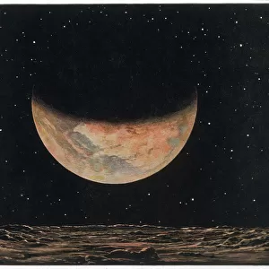
Mars. Composite satellite image of the surface of Mars, showing the north polar cap (white), a mixture of ice and dust that extends to the 80 degree latitude circle. Mars northern hemisphere is characterised by vast, sparsely cratered plains with high volcanoes. Its southern hemisphere is highly cratered and features large canyon systems such as Valles Marineris, which is 4000 kilometres in length (seen here at bottom). This image was created using data from the Mars Global Surveyor spacecrafts Mars Orbiter Laser Altimeter
Science Photo Library features Science and Medical images including photos and illustrations
Media ID 6426717
© DETLEV VAN RAVENSWAAY/SCIENCE PHOTO LIBRARY
Astrophysical Astrophysics Canyon Canyons Circle Circular Composite Crater Cratered Craters Feature Features From Space Globe Ice Cap Impact Mapped Mars Mars Global Surveyor Mars Orbiter Laser Altimeter Martian Mola North Plain Plains Planetary Planetary Science Polar Region Regions Round Satellite Image Solar System Space Craft Surface System Systems Topographic Topographical Topography Valles Marineris Volcano Volcanoes Northen Polar Cap
FEATURES IN THESE COLLECTIONS
> Animals
> Fishes
> M
> Mola Mola
> Animals
> Mammals
> Muridae
> Plains Mouse
> Maps and Charts
> Related Images
> Science
> Space Exploration
> Planets
> Mars
> Science
> Space Exploration
> Solar System
EDITORS COMMENTS
This print showcases a composite satellite image of Mars, revealing the mesmerizing features that define the red planet. The image highlights the north polar cap, an awe-inspiring blend of ice and dust extending to the 80-degree latitude circle. As we explore further, Mars' northern hemisphere unfolds with its vast plains adorned by sporadic craters and towering volcanoes. In stark contrast, the southern hemisphere boasts a highly cratered terrain, featuring colossal canyon systems like Valles Marineris stretching an astonishing 4000 kilometers in length. Crafted using data from the Mars Global Surveyor spacecraft's Mars Orbiter Laser Altimeter (MOLA), this remarkable image offers us a glimpse into Martian topography on a grand scale. From circular formations to expansive plains and intricate canyon networks, every inch of this celestial body is meticulously mapped out. As we delve deeper into our understanding of this enigmatic planet through astrophysics and planetary science, images like these fuel our curiosity about what lies beyond Earth's boundaries. This composite satellite image serves as a testament to human ingenuity in unraveling the mysteries of our solar system. Captured by Science Photo Library's expertise in astronomical photography, this print invites us to marvel at Mars' unique beauty while igniting our imagination about future explorations within our neighboring world.
MADE IN THE USA
Safe Shipping with 30 Day Money Back Guarantee
FREE PERSONALISATION*
We are proud to offer a range of customisation features including Personalised Captions, Color Filters and Picture Zoom Tools
SECURE PAYMENTS
We happily accept a wide range of payment options so you can pay for the things you need in the way that is most convenient for you
* Options may vary by product and licensing agreement. Zoomed Pictures can be adjusted in the Cart.