Home > Aerial Photography > Related Images
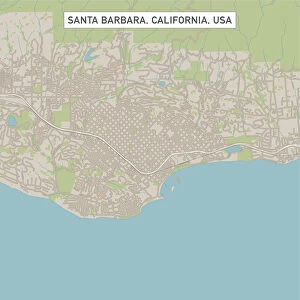
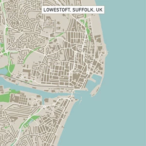
Bakersfield California US City Street Map

![]()
Wall Art and Photo Gifts from Fine Art Storehouse
Bakersfield California US City Street Map
Vector Illustration of a City Street Map of Bakersfield, California, USA. Scale 1:60, 000.
All source data is in the public domain.
U.S. Geological Survey, US Topo
Used Layers:
USGS The National Map: National Hydrography Dataset (NHD)
USGS The National Map: National Transportation Dataset (NTD)
Unleash your creativity and transform your space into a visual masterpiece!
Frank Ramspott
Media ID 15055149
© Frank Ramspott, all rights reserved
Aerial View California City Map Computer Graphic Directly Above Downtown District Gray Road Map Text Bakersfield Digitally Generated Image Green Color White Color
FEATURES IN THESE COLLECTIONS
> Aerial Photography
> Related Images
> Animals
> Insects
> Hemiptera
> Green Scale
> Animals
> Mammals
> Cricetidae
> California Mouse
> Arts
> Contemporary art
> Digital artwork
> Street art
> Arts
> Landscape paintings
> Waterfall and river artworks
> River artworks
> Arts
> Portraits
> Pop art gallery
> Street art portraits
> Arts
> Street art graffiti
> Digital art
> Digital paintings
> Arts
> Street art graffiti
> Digital art
> Vector illustrations
> Fine Art Storehouse
> Map
> Street Maps
> Fine Art Storehouse
> Map
> USA Maps
> Maps and Charts
> Geological Map
> Maps and Charts
> Related Images
EDITORS COMMENTS
This print showcases a meticulously detailed city street map of Bakersfield, California, USA. The vector illustration presents an aerial view of the downtown district, with the Kern River meandering through the landscape and a serene lake adding to its charm. Every intricate street and road is accurately depicted in this visually stunning piece, designed at a scale of 1:60,000. The artist behind this masterpiece, Frank Ramspott, has ingeniously utilized various layers from public domain sources such as USGS The National Map: National Hydrography Dataset (NHD) and USGS The National Map: National Transportation Dataset (NTD). This ensures that every element on the map is authentic and true to life. The color palette chosen for this digitally generated image adds depth and vibrancy to the composition. Shades of gray represent roads while green symbolizes natural areas like parks or open spaces. Blue hues depict water bodies such as rivers and lakes while white text provides clarity for easy navigation. With no people present in the scene, viewers can focus solely on appreciating the artistry involved in creating this remarkable cartographic representation. It serves as both an informative tool for residents and visitors alike while also being a visually appealing work of art suitable for any space. Whether you are a lover of maps or simply admire exceptional design work, this Bakersfield city street map print by Frank Ramspott will undoubtedly captivate your imagination.
MADE IN THE USA
Safe Shipping with 30 Day Money Back Guarantee
FREE PERSONALISATION*
We are proud to offer a range of customisation features including Personalised Captions, Color Filters and Picture Zoom Tools
SECURE PAYMENTS
We happily accept a wide range of payment options so you can pay for the things you need in the way that is most convenient for you
* Options may vary by product and licensing agreement. Zoomed Pictures can be adjusted in the Cart.