Home > Arts > Landscape paintings > Waterfall and river artworks > River artworks
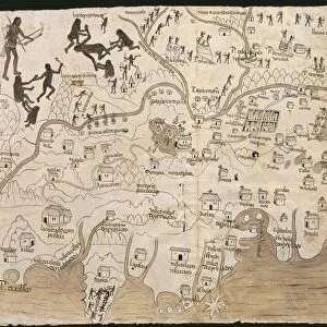
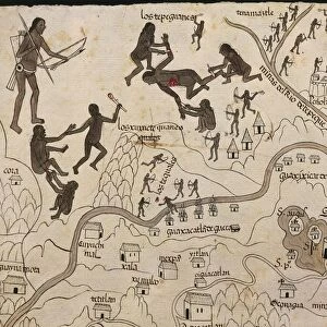
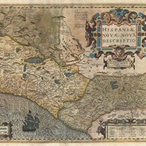
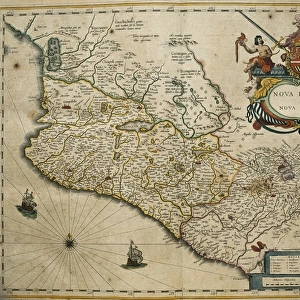
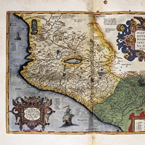
MEXICO: MIXTEC MAP. Map drawn by the Mixtecs of ancient Mexico, 8th-15th century

![]()
Wall Art and Photo Gifts from Granger
MEXICO: MIXTEC MAP. Map drawn by the Mixtecs of ancient Mexico, 8th-15th century
MEXICO: MIXTEC MAP.
Map drawn by the Mixtecs of ancient Mexico, 8th-15th century
Granger holds millions of images spanning more than 25,000 years of world history, from before the Stone Age to the dawn of the Space Age
Media ID 12417986
10th Century 11th Century 12th Century 13th Century 14th Century 15th Century 8th Century 9th Century Codex Footprint Latin America Latin American Manuscript Mesoamerica Mesoamerican Mexican Mexico Mixtec Native American Path Precolombian Primitive
FEATURES IN THESE COLLECTIONS
> Arts
> Landscape paintings
> Waterfall and river artworks
> River artworks
> Granger Art on Demand
> World History
> Maps and Charts
> Early Maps
> Maps and Charts
> World
> North America
> Mexico
> Maps
EDITORS COMMENTS
This print showcases a remarkable piece of history - the Mixtec Map drawn by the ancient Mixtecs of Mexico between the 8th and 15th centuries. The intricate details and craftsmanship displayed in this map are truly awe-inspiring, offering us a glimpse into the rich cultural heritage of Mesoamerica. The Mixtec Map is an invaluable artifact that reflects the indigenous knowledge and geographical understanding of its creators. It takes us on a journey through time, unraveling the paths, rivers, and footprints left behind by these ancient people. As we explore this mesmerizing artwork, we can't help but marvel at their advanced cartographic skills. This masterpiece serves as a testament to the ingenuity and creativity of native peoples in Latin America. Its vibrant colors and meticulous illustrations transport us back to an era when maps were not just tools for navigation but also works of art that conveyed stories about land, culture, and identity. As we delve deeper into this photograph's details, it becomes evident that it is more than just an image; it represents resilience, wisdom, and ancestral connections. It reminds us to appreciate our shared human history while celebrating diverse cultures that have shaped our world. Granger Art on Demand has beautifully captured this extraordinary piece from their carousel collection without commercial intentions. Through their lens, they allow us to cherish such treasures from afar while igniting curiosity about ancient civilizations like never before.
MADE IN THE USA
Safe Shipping with 30 Day Money Back Guarantee
FREE PERSONALISATION*
We are proud to offer a range of customisation features including Personalised Captions, Color Filters and Picture Zoom Tools
FREE COLORIZATION SERVICE
You can choose advanced AI Colorization for this picture at no extra charge!
SECURE PAYMENTS
We happily accept a wide range of payment options so you can pay for the things you need in the way that is most convenient for you
* Options may vary by product and licensing agreement. Zoomed Pictures can be adjusted in the Cart.