Home > Universal Images Group (UIG) > Universal Images Group > Universal History Archive > History
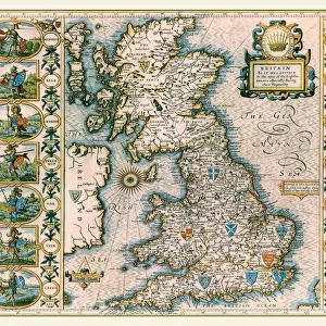
1658 map of the Dutch Republic

![]()
Wall Art and Photo Gifts from Universal Images Group (UIG)
1658 map of the Dutch Republic
1658 map of the Dutch Republic. The Dutch Republic was known as the Republic of the Seven United Netherlands (Republiek der Zeven Verenigde Nederlanden) existed 1581 to 1795
Universal Images Group (UIG) manages distribution for many leading specialist agencies worldwide
Media ID 9633277
© Universal History Archive/UIG
1658 Multi Colored Netherlands Dutch Republic
EDITORS COMMENTS
This print showcases a remarkable piece of history - the 1658 map of the Dutch Republic. Also known as the Republic of the Seven United Netherlands, this powerful nation existed from 1581 to 1795. The map, presented in a horizontal format, is a vibrant display of multi-colored cartography that beautifully captures the essence of this influential era. As we gaze upon this illustration and painting, we are transported back in time to an age when the Dutch Republic was at its zenith. With intricate details and precise markings, this map offers us a glimpse into the vast territories controlled by these seven united provinces. The Dutch Republic's rich history unfolds before our eyes through this extraordinary artwork. It reminds us of their maritime prowess and global influence during an era marked by exploration and trade dominance. From bustling cities to expansive waterways, every corner is meticulously depicted on this historical treasure. While no people are present within this image, it serves as a testament to human ingenuity and ambition. It invites us to reflect on how societies evolve over time while leaving lasting imprints on our world. Thanks to Universal Images Group (UIG), we can now appreciate and preserve this invaluable snapshot from centuries past. Let us cherish such visual treasures that connect us with our collective heritage and inspire curiosity about those who came before us.
MADE IN THE USA
Safe Shipping with 30 Day Money Back Guarantee
FREE PERSONALISATION*
We are proud to offer a range of customisation features including Personalised Captions, Color Filters and Picture Zoom Tools
SECURE PAYMENTS
We happily accept a wide range of payment options so you can pay for the things you need in the way that is most convenient for you
* Options may vary by product and licensing agreement. Zoomed Pictures can be adjusted in the Cart.