Home > Arts > Artists > O > Oceanic Oceanic
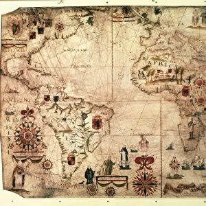
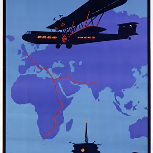
Navigation map by Visconte Maggiolo, 1504

![]()
Wall Art and Photo Gifts from Universal Images Group (UIG)
Navigation map by Visconte Maggiolo, 1504
Cartography, 15th century. Navigation maps created by Visconte Maggiolo, 1504
Universal Images Group (UIG) manages distribution for many leading specialist agencies worldwide
Media ID 9572047
© DEA PICTURE LIBRARY
16th Century Africa Atlantic Ocean Crossing Direction Guidance Indian Ocean Line Wind Rose
FEATURES IN THESE COLLECTIONS
> Africa
> Related Images
> Arts
> Artists
> O
> Oceanic Oceanic
> Maps and Charts
> Related Images
> Universal Images Group (UIG)
> Art
> Painting, Sculpture & Prints
> Cartography
EDITORS COMMENTS
This print showcases the remarkable navigation map created by Visconte Maggiolo in 1504, offering a glimpse into the intricate world of cartography during the 15th century. The image takes us back to an era when explorers and sailors relied on such maps to traverse vast oceans and discover new lands. The map's detailed depiction of the Atlantic Ocean immediately catches our attention, with its carefully drawn lines indicating various routes and crossings. It serves as a testament to the immense courage and determination of those who ventured across these treacherous waters in search of adventure and riches. As we examine this historical artifact, our eyes are drawn towards Africa, strategically positioned at the center of this horizontal composition. This continent played a pivotal role in shaping global trade routes during that time period, making it an essential point for navigation. One cannot help but notice the wind rose prominently displayed on this map, providing crucial guidance for sailors seeking favorable winds to propel their vessels forward. This element highlights both the scientific precision and artistic craftsmanship employed by Maggiolo in his work. Through this print from Universal Images Group (UIG), we are transported back in time to witness a significant moment in history where physical geography met artistry. It reminds us of how far humanity has come in terms of travel and exploration while also honoring those early pioneers who dared to venture into uncharted territories using nothing more than their wits and navigational tools like Maggiolo's masterpiece.
MADE IN THE USA
Safe Shipping with 30 Day Money Back Guarantee
FREE PERSONALISATION*
We are proud to offer a range of customisation features including Personalised Captions, Color Filters and Picture Zoom Tools
SECURE PAYMENTS
We happily accept a wide range of payment options so you can pay for the things you need in the way that is most convenient for you
* Options may vary by product and licensing agreement. Zoomed Pictures can be adjusted in the Cart.