Home > Arts > Landscape paintings > Waterfall and river artworks > River artworks
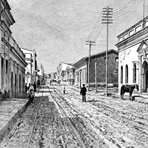
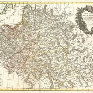
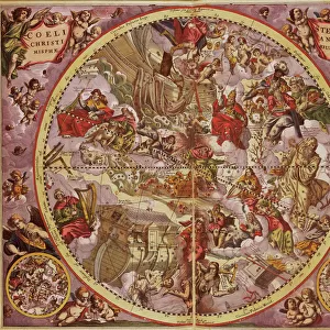
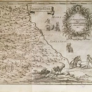
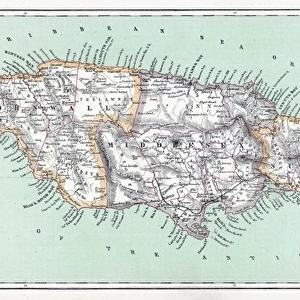
Map of Jamaica, Port Royal before earthquake in 1692, From Journal by Edward Barlow

![]()
Wall Art and Photo Gifts from Universal Images Group (UIG)
Map of Jamaica, Port Royal before earthquake in 1692, From Journal by Edward Barlow
Cartography, Jamaica, 17th century. Port Royal before the earthquake in 1692. From the Journal by Edward Barlow
Universal Images Group (UIG) manages distribution for many leading specialist agencies worldwide
Media ID 9504471
© DEA PICTURE LIBRARY
17th Century Coastline Colonialism Exploration Geography Guidance Handwriting Harbor Jamaica Page River Sailing Ship Sealife Transportation Animal Representation Port Royal
FEATURES IN THESE COLLECTIONS
> Arts
> Landscape paintings
> Waterfall and river artworks
> River artworks
> North America
> Jamaica
> Maps
> Universal Images Group (UIG)
> Art
> Painting, Sculpture & Prints
> Cartography
EDITORS COMMENTS
This print takes us back to the 17th century, showcasing a detailed map of Jamaica's Port Royal before it was devastated by an earthquake in 1692. The image is derived from Edward Barlow's Journal, offering valuable insights into the colonial era and the art of cartography during that time. The map itself is a testament to the meticulous craftsmanship of Barlow, highlighting various elements crucial for navigation and exploration. From intricate illustrations of sailing ships gracefully gliding through the harbor to delicate representations of animals and sealife along the coastline, every detail tells a story waiting to be unraveled. As we delve deeper into this studio shot, we can almost feel transported back in time. The vertical composition allows us to appreciate each stroke of Barlow's brush as he meticulously captured every river, bay, and transportation route with utmost precision. Handwritten annotations further enhance our understanding of this historical document. Beyond its aesthetic appeal lies a wealth of knowledge about Jamaica's geography and maritime significance during colonial times. This print serves as both a visual delight for enthusiasts interested in exploring history through maps and an invaluable resource for researchers studying early cartography techniques
MADE IN THE USA
Safe Shipping with 30 Day Money Back Guarantee
FREE PERSONALISATION*
We are proud to offer a range of customisation features including Personalised Captions, Color Filters and Picture Zoom Tools
SECURE PAYMENTS
We happily accept a wide range of payment options so you can pay for the things you need in the way that is most convenient for you
* Options may vary by product and licensing agreement. Zoomed Pictures can be adjusted in the Cart.