Home > Universal Images Group (UIG) > Art > Painting, Sculpture & Prints > Cartography
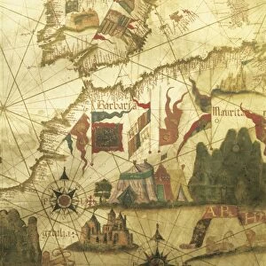
Map of Greece, Rhodes Island, from the Latin manuscript, by Insularium Arcipelagi

![]()
Wall Art and Photo Gifts from Universal Images Group (UIG)
Map of Greece, Rhodes Island, from the Latin manuscript, by Insularium Arcipelagi
Cartography, Greece, 15th century. Rhodes Island. From the Latin manuscript, Insularium Arcipelagi
Universal Images Group (UIG) manages distribution for many leading specialist agencies worldwide
Media ID 9501775
© DEA / A. DAGLI ORTI
15th Century Aerial View Boundary Castle Field Greece Guidance House Human Settlement Latin Script Navigational Equipment Protection Safety Text Tower Town Townscape Non Urban Scene Rhodes Island
EDITORS COMMENTS
This print showcases a remarkable piece of history, the Map of Greece, Rhodes Island. Dating back to the 15th century and originating from the Latin manuscript, Insularium Arcipelagi, this map offers a fascinating glimpse into ancient cartography. The intricate details and precision displayed in this artwork highlight the skill and craftsmanship of its creator. The aerial view depicted in this vertical composition allows us to appreciate not only the topography but also the architectural marvels that adorned Rhodes Island during that era. From towering castles to majestic churches, each structure tells a story of human settlement and cultural heritage. As we explore this non-urban scene captured on a sunny day, our eyes are drawn to the boundaries demarcating towns and fields. This map served as both guidance for travelers navigating through Greece and as protection for those seeking safety within its walls. The inclusion of text written in Latin script adds an additional layer of historical significance to this artful representation. It serves as navigational equipment for understanding ancient Greek geography while providing insight into how knowledge was shared during that time period. This print is more than just an illustration or painting; it is a portal into another era—a testament to our fascination with history and our desire to preserve it for future generations.
MADE IN THE USA
Safe Shipping with 30 Day Money Back Guarantee
FREE PERSONALISATION*
We are proud to offer a range of customisation features including Personalised Captions, Color Filters and Picture Zoom Tools
SECURE PAYMENTS
We happily accept a wide range of payment options so you can pay for the things you need in the way that is most convenient for you
* Options may vary by product and licensing agreement. Zoomed Pictures can be adjusted in the Cart.