Home > Universal Images Group (UIG) > Art > Painting, Sculpture & Prints > Cartography
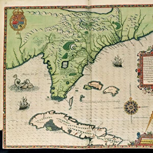
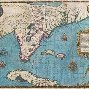
Map of Florida and Cuba by Theodore de Bry, 1563

![]()
Wall Art and Photo Gifts from Universal Images Group (UIG)
Map of Florida and Cuba by Theodore de Bry, 1563
Cartography, 16th century. Map of Florida and Cuba by Theodore de Bry, 1563
Universal Images Group (UIG) manages distribution for many leading specialist agencies worldwide
Media ID 9505305
© DEA / G. DAGLI ORTI
16th Century Coastline Coat Of Arms Compass Rose Cuba Florida Island Nautical Vessel Peninsula Sailing Boat Transportation Western Script Animal Representation Theodore De Bry
EDITORS COMMENTS
This print showcases a remarkable piece of cartography from the 16th century. Created by Theodore de Bry in 1563, this Map of Florida and Cuba is a true testament to the artistry and precision of early mapmaking. The print captures the intricate details and vibrant colors that bring this historical artifact to life. The map depicts both Florida and Cuba, two significant landmasses during this period. With its carefully drawn coastlines, peninsula formations, and even a sailing boat gracefully gliding through the sea, it offers a glimpse into the past when exploration was at its peak. One cannot help but be fascinated by the inclusion of various elements such as animal representations scattered across the map's surface. These artistic touches add an extra layer of intrigue to an already captivating piece. The presence of a compass rose further emphasizes the importance placed on navigation during this era. It serves as a reminder that maps like these were not only beautiful works of art but also practical tools for those venturing into uncharted territories. With no people present in this studio shot photograph, our focus is solely on appreciating the craftsmanship behind De Bry's creation. This stunning image transports us back in time, allowing us to marvel at how far we have come in terms of understanding physical geography and mapping techniques
MADE IN THE USA
Safe Shipping with 30 Day Money Back Guarantee
FREE PERSONALISATION*
We are proud to offer a range of customisation features including Personalised Captions, Color Filters and Picture Zoom Tools
SECURE PAYMENTS
We happily accept a wide range of payment options so you can pay for the things you need in the way that is most convenient for you
* Options may vary by product and licensing agreement. Zoomed Pictures can be adjusted in the Cart.