Home > Stocktrek Images > Space
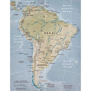
Topographic view of South America

![]()
Wall Art and Photo Gifts from Stocktrek
Topographic view of South America
This image of South America was generated with data from the Shuttle Radar Topography Mission (SRTM).
Topographic relief in South America is dominated by the Andes Mountains, which extend all along the Pacific Coast. These mountains are created primarily by the convergence of the Nazca and South American tectonic plates. The Nazca Plate, which underlies the eastern Pacific Ocean, slides under western South America resulting in crustal thickening, uplift, and volcanism. Another zone of plate convergence occurs along the northwestern coast of South America where the Caribbean Plate also slides under the South American Plate and forms the northeastern extension of the Andes Mountains.
East of the Andes, much of northern South America drains into the Amazon River, the worlds largest river in terms of both watershed area and flow volume. Topographic relief is very low in much of the Amazon Basin but SRTM data provide an excellent detailed look at the basins three-dimensional drainage pattern, including the geologic structural trough (syncline) that hosts the eastern river channel.
North of the Amazon, the Guiana Highlands commonly stand in sharp contrast to the surrounding lowlands, indeed hosting the worlds tallest waterfall, Angel Falls (979 meters or 3212 feet). Folded and fractured bedrock structures are distinctive in the topographic pattern
Stocktrek Images specializes in Astronomy, Dinosaurs, Medical, Military Forces, Ocean Life, & Sci-Fi
Media ID 13066077
© Stocktrek Images
Continent Earth Science Geography Geophysics Geoscience Land Feature Landform Relief Map South America Topography View From Space
EDITORS COMMENTS
This print showcases the stunning topographic view of South America, meticulously generated with data from the Shuttle Radar Topography Mission (SRTM). The dominant feature that captures our attention is the majestic Andes Mountains, stretching along the entire Pacific Coast. These awe-inspiring mountains owe their existence to the convergence of two tectonic plates: the Nazca Plate and the South American Plate. As the Nazca Plate slides beneath western South America, it triggers crustal thickening, uplift, and volcanic activity. Moving eastward from the Andes, we encounter another remarkable sight – much of northern South America drains into none other than the mighty Amazon River. With its vast watershed area and colossal flow volume, this river holds an unrivaled status as a natural wonder. While topographic relief in most parts of the Amazon Basin appears low at first glance, SRTM data unveils intricate details about its three-dimensional drainage pattern. Notably, it reveals a geologic structural trough known as a syncline that cradles the eastern river channel. Venturing further north beyond the Amazon lies an extraordinary landscape known as Guiana Highlands. This region stands in stark contrast to its surrounding lowlands and boasts Angel Falls – nature's masterpiece towering at an astounding height of 979 meters (3212 feet), making it Earth's tallest waterfall. One cannot help but notice distinctive folded and fractured bedrock structures scattered throughout this mesmerizing topographic pattern. In summary, this exceptional print by Stocktrek Images offers us a glimpse into South America's breathtaking terrain while highlighting its geological wonders without any commercial intent or affiliation mentioned within this caption.
MADE IN THE USA
Safe Shipping with 30 Day Money Back Guarantee
FREE PERSONALISATION*
We are proud to offer a range of customisation features including Personalised Captions, Color Filters and Picture Zoom Tools
SECURE PAYMENTS
We happily accept a wide range of payment options so you can pay for the things you need in the way that is most convenient for you
* Options may vary by product and licensing agreement. Zoomed Pictures can be adjusted in the Cart.