Home > Science > Space Exploration > Planets > Earth
North America, satellite image

![]()
Wall Art and Photo Gifts from Science Photo Library
North America, satellite image
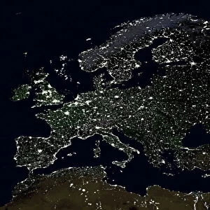
North America, satellite image. Oceans are blue and land is green and brown. South America (bottom right) and the Arctic (top, white) are also seen, along with the Atlantic Ocean (right) and the Pacific Ocean (left). This image was produced by combining data from the Defense Meteorological Satellite Program (DMSP) and NOas POES and Nimbus 7 satellites
Science Photo Library features Science and Medical images including photos and illustrations
Media ID 1705069
© PLANETARY VISIONS LTD/SCIENCE PHOTO LIBRARY
Arctic Atlantic Caribbean Central America Combined Data Continent Continents Day Time Defense Meteorological Dmsp Earth Observation Earth Science From Space Globe Island Land Land Cover Nimbus 7 Noaa North Pole Pacific Poes Polar Orbiter Region Satellite Satellite Image Satellite Program Satellites South America Topographical Topography Us A Vegetation World Pacific Islands
FEATURES IN THESE COLLECTIONS
> Arts
> Artists
> O
> Oceanic Oceanic
> Europe
> France
> Canton
> Landes
> North America
> Related Images
> Popular Themes
> North Island
> Science Photo Library
> Aerial and Satellite
> Science
> Space Exploration
> Planets
> Earth
> South America
> Related Images
MADE IN THE USA
Safe Shipping with 30 Day Money Back Guarantee
FREE PERSONALISATION*
We are proud to offer a range of customisation features including Personalised Captions, Color Filters and Picture Zoom Tools
SECURE PAYMENTS
We happily accept a wide range of payment options so you can pay for the things you need in the way that is most convenient for you
* Options may vary by product and licensing agreement. Zoomed Pictures can be adjusted in the Cart.