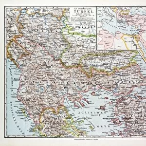
1906 San Francisco quake intensity map

![]()
Wall Art and Photo Gifts from Science Photo Library
1906 San Francisco quake intensity map
1906 San Francisco earthquake intensity map, as applied to the area in 2003. The earthquake of 18th April 1906 had a magnitude of around 7.9. The quake itself, and the subsequent fires, led to the deaths of over 3000 people, and some 300, 000 out of the citys 400, 000 inhabitants were left homeless. This intensity map is based on current knowledge of the earthquakes strength and source, and of the surrounding rock types. The quake was due to a slip in the San Andreas fault (thick black line). Shaking intensity is colour-coded, from red (extreme) through orange (severe) and yellow (strong) to green (moderate). This map was made in the run-up to the centenary of the event, to help model what damage would be likely to occur in this heavily-populated area in future quakes. San Francisco occupies the southern peninsula enclosing the bay
Science Photo Library features Science and Medical images including photos and illustrations
Media ID 6341231
© US GEOLOGICAL SURVEY/SCIENCE PHOTO LIBRARY
1900s 1906 2003 2006 Anniversary California Centenary Cities City Earth Observation Earthquake Future Geological North American Plan Prediction San Andreas Fault Seismology Shaking Urban Us A Bay Area Computer Artwork
EDITORS COMMENTS
This print showcases a historical artifact that holds immense significance in understanding the devastating impact of the 1906 San Francisco earthquake. The intensity map, created in 2003, provides valuable insights into the strength and source of this catastrophic event. With a magnitude of approximately 7.9, the earthquake and subsequent fires claimed over 3000 lives while rendering nearly 300,000 inhabitants homeless out of a population of 400,000. The map's color-coded representation vividly portrays shaking intensity levels ranging from red (extreme) to orange (severe), yellow (strong), and green (moderate). It was meticulously crafted using current knowledge about the earthquake's force and origin as well as an understanding of surrounding rock types. A thick black line signifies the slip in the notorious San Andreas fault which triggered this calamity. Commissioned ahead of its centenary anniversary, this illustration aimed to assist experts in modeling potential damage caused by future earthquakes within this densely populated area. As San Francisco occupies the southern peninsula enclosing the bay with its iconic urban landscape, comprehending such seismic events becomes crucial for effective disaster planning and prediction. Through computer artwork based on earth observation data and seismology research, this image serves as both a geographical record and a reminder of our vulnerability to natural disasters. Its historical value lies not only in commemorating past tragedies but also in fostering resilience for cities across North America facing similar threats in the twenty-first century.
MADE IN THE USA
Safe Shipping with 30 Day Money Back Guarantee
FREE PERSONALISATION*
We are proud to offer a range of customisation features including Personalised Captions, Color Filters and Picture Zoom Tools
SECURE PAYMENTS
We happily accept a wide range of payment options so you can pay for the things you need in the way that is most convenient for you
* Options may vary by product and licensing agreement. Zoomed Pictures can be adjusted in the Cart.