Home > Animals > Mammals > Beaver
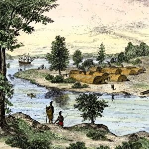
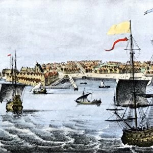
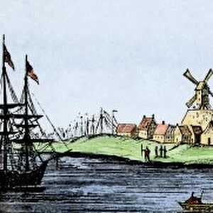
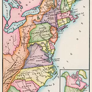
Dutch map of eastern North America, 1670

![]()
Wall Art and Photo Gifts from North Wind
Dutch map of eastern North America, 1670
Nova Belgh Tabula, map of New Netherland and New England, 1670.
Hand-colored woodcut reproduction
North Wind Picture Archives brings history to life with stock images and hand-colored illustrations
Media ID 5880395
© North Wind Picture Archives
1600s 17th Century America Artifact Beaver Canada Canadian Chart Colonial Colony Discover Discovery Document Eastern Exploration Explore French French Canada Hudson River Indian Iroquois Lake Champlain Native American New England New France New Netherland Quebec 1670 Mink
FEATURES IN THESE COLLECTIONS
> Animals
> Mammals
> Castoridae
> American Beaver
> Animals
> Mammals
> Mustelidae
> American Mink
> Arts
> Landscape paintings
> Waterfall and river artworks
> River artworks
> Europe
> France
> Lakes
> Related Images
> Europe
> United Kingdom
> England
> Lakes
> Europe
> United Kingdom
> England
> Maps
> Europe
> United Kingdom
> England
> Rivers
> Historic
> Ancient artifacts and relics
> North Wind Picture Archives
> Exploration
> North Wind Picture Archives
> Maps
EDITORS COMMENTS
This hand-colored woodcut reproduction of a Dutch map from 1670 takes us back to the early days of exploration and colonization in eastern North America. The Nova Belgh Tabula, also known as the map of New Netherland and New England, offers a glimpse into the rich history and heritage of this region. The intricate illustration showcases the vastness of this uncharted territory with its detailed depiction of rivers, lakes, and coastlines. It highlights significant landmarks such as the Hudson River, Lake Champlain, and Quebec while showcasing the colonial presence through symbols like beavers representing trade and minks symbolizing fur trapping. As we study this artifact from the 17th century, we are transported to an era when Native American tribes like the Iroquois played a vital role in shaping these lands. This map serves as both a document of discovery for European explorers and a testament to indigenous cultures that thrived long before their arrival. With its vintage charm and artistic flair, this print is not only an educational tool but also a piece of art that captures our imagination. It reminds us how far we have come since those early days while honoring our shared past. Whether you are an avid historian or simply appreciate beautiful craftsmanship, this Dutch map invites you on a journey through time to explore the roots of North America's diverse tapestry.
MADE IN THE USA
Safe Shipping with 30 Day Money Back Guarantee
FREE PERSONALISATION*
We are proud to offer a range of customisation features including Personalised Captions, Color Filters and Picture Zoom Tools
SECURE PAYMENTS
We happily accept a wide range of payment options so you can pay for the things you need in the way that is most convenient for you
* Options may vary by product and licensing agreement. Zoomed Pictures can be adjusted in the Cart.