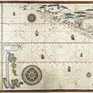
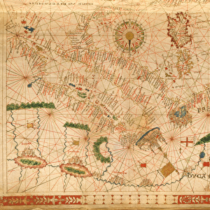
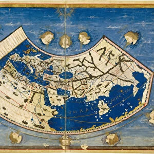
Portolan chart, 1591. Map of the North Atlantic

![]()
Wall Art and Photo Gifts from Mary Evans Picture Library
Portolan chart, 1591. Map of the North Atlantic
Portolan chart, 1591. Map of the North Atlantic Ocean. Miniature Painting
Mary Evans Picture Library makes available wonderful images created for people to enjoy over the centuries
Media ID 8284449
© Mary Evans/M.C.Esteban/Iberfoto
Atlantic Cartography Chart Commerce Commerces Commercial Geographic Geographical Geography Illuminated Manuscript Manuscripts Miniatures Navigation Portolan Sail Trades
EDITORS COMMENTS
This exquisite Portolan chart, created in 1591, offers a captivating glimpse into the geographical knowledge and maritime exploration of the late Renaissance period. The North Atlantic Ocean is meticulously depicted, with intricate detail and vibrant colors, revealing the known world as it was understood at the time. The chart is a testament to the advancements in cartography and navigation, as evidenced by the precise representation of coastlines, islands, and sea routes. The map's illuminated borders and decorative elements add to its aesthetic appeal, making it a valuable addition to any collection of historical manuscripts or miniatures. The North Atlantic was a significant body of water during this era due to its role in transatlantic trade and exploration. The map reveals the known trading routes between Europe, the Americas, and Africa, with various ports and settlements marked along the way. The chart's intricate depiction of the coastlines of North America, Europe, and the islands of the Caribbean and the Azores, highlights the extensive knowledge of the region's geography that was available to navigators and traders at the time. The Portolan chart is a fascinating artifact of the past, providing a window into the maritime world of the late 16th century. Its intricate details and decorative elements make it a beautiful work of art, while its geographical information offers valuable insights into the history of exploration and commerce during the Age of Discovery.
MADE IN THE USA
Safe Shipping with 30 Day Money Back Guarantee
FREE PERSONALISATION*
We are proud to offer a range of customisation features including Personalised Captions, Color Filters and Picture Zoom Tools
SECURE PAYMENTS
We happily accept a wide range of payment options so you can pay for the things you need in the way that is most convenient for you
* Options may vary by product and licensing agreement. Zoomed Pictures can be adjusted in the Cart.