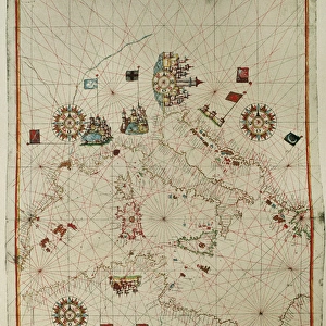
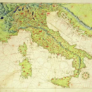
Portolan atlas by Joan Martines (1556-1590). Messina
. Messina")
![]()
Wall Art and Photo Gifts from Mary Evans Picture Library
Portolan atlas by Joan Martines (1556-1590). Messina
Portolan atlas of the world by Joan Martines (1556-1590). Messina, 1587. National Library. Madrid. Spain
Mary Evans Picture Library makes available wonderful images created for people to enjoy over the centuries
Media ID 14404520
© Thaliastock / Mary Evans
1587 Area Atlas Biblioteca Cartography Chart Colours Element Geography Illuminated Joan Manuscript Martines Messina Nacional Cartographical Cosmographer
EDITORS COMMENTS
This stunning image showcases a page from the Portolan Atlas, a cartographical masterpiece created by Joan Martines in Messina, Sicily, in 1587. The atlas, now held in the National Library of Spain, is a testament to the advanced cartographic knowledge of the late 16th century. The Portolan Atlas is renowned for its decorative elements and vibrant colors, which add to its aesthetic appeal. The map depicted here illustrates the Mediterranean Sea and its surrounding coasts, meticulously charted and adorned with intricate details. The use of color distinguishes different regions, making it easier for navigators to identify various areas and landmarks. Joan Martines, a cosmographer, dedicated considerable time and effort to the production of this atlas. The map's decorative elements, such as the elaborate cartouche in the bottom right corner, further enhance its visual appeal. The atlas was an essential tool for seafarers during the Age of Discovery, providing them with accurate and detailed information about the world's coastlines. The Portolan Atlas is a significant historical artifact, offering valuable insights into the geographical knowledge of the late 16th century. Its intricate details and decorative elements make it a fascinating piece of medieval cartography and a must-see for anyone interested in the history of cartography and exploration.
MADE IN THE USA
Safe Shipping with 30 Day Money Back Guarantee
FREE PERSONALISATION*
We are proud to offer a range of customisation features including Personalised Captions, Color Filters and Picture Zoom Tools
SECURE PAYMENTS
We happily accept a wide range of payment options so you can pay for the things you need in the way that is most convenient for you
* Options may vary by product and licensing agreement. Zoomed Pictures can be adjusted in the Cart.