Home > Arts > Artists > O > Oceanic Oceanic
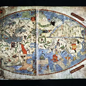
Map of the Indian Ocean 1700 Date: 1700

![]()
Wall Art and Photo Gifts from Mary Evans Picture Library
Map of the Indian Ocean 1700 Date: 1700
Mary Evans Picture Library makes available wonderful images created for people to enjoy over the centuries
Media ID 20184148
© The Pictures Now Image Collection / Bubblepunk
1700 Antiquarian Antique Away Coasts Crew Dreams Explorer Journey Journeys Maps Orient Stands Surrounded Travels Treks Trip Trips Voyage Voyages
FEATURES IN THESE COLLECTIONS
> Africa
> Related Images
> Arts
> Artists
> O
> Oceanic Oceanic
> Asia
> Related Images
> Maps and Charts
> Related Images
> Mary Evans Prints Online
> Pictures Now
> Oceania
> Australia
> Related Images
EDITORS COMMENTS
A captivating and antiquated view of the Indian Ocean as depicted in an exquisite map dated 1700. This map, a treasure from the annals of cartographic history, invites us to embark on a journey back in time, when intrepid explorers set sail from the shores of Africa, Asia, and Europe, driven by curiosity, dreams, and the allure of discovery. The Indian Ocean, a vast expanse of water that surrounds the Indian subcontinent, is depicted in all its splendor, with its intricate coastlines, islands, and waterways meticulously charted. The map reveals a world that was still largely unknown to Europeans at the time, filled with the promise of new lands, cultures, and resources. At the heart of the map, the Indian subcontinent stands out, with its intricate detailing of the major rivers, mountains, and cities. To the east, the vast expanse of the Pacific Ocean is shown, with the islands of Indonesia and Australia hinted at in the distance. To the west, the Arabian Peninsula and the Horn of Africa are depicted, with the Red Sea and the Gulf of Aden providing crucial shipping lanes for ancient maritime trade. This map, a testament to the human spirit of exploration and the desire to chart the unknown, is a reminder of the incredible journeys and voyages that have shaped our world. As we gaze upon it, we can almost hear the creaking of the ship's timbers, feel the salt spray on our faces, and sense the excitement and anticipation of the crew as they set sail on their next great adventure.
MADE IN THE USA
Safe Shipping with 30 Day Money Back Guarantee
FREE PERSONALISATION*
We are proud to offer a range of customisation features including Personalised Captions, Color Filters and Picture Zoom Tools
SECURE PAYMENTS
We happily accept a wide range of payment options so you can pay for the things you need in the way that is most convenient for you
* Options may vary by product and licensing agreement. Zoomed Pictures can be adjusted in the Cart.