Home > Europe > United Kingdom > England > Surrey > Dorking
Ordnance Survey map cover - Dorking and Leith Hill

![]()
Wall Art and Photo Gifts from Mary Evans Picture Library
Ordnance Survey map cover - Dorking and Leith Hill
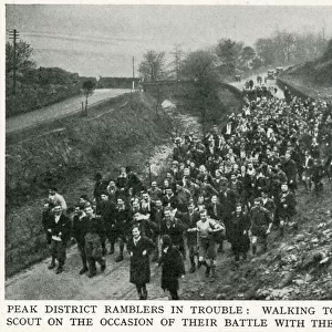
Front cover of an Ordnance Survey map covering the Dorking and Leith Hill area of Surrey. The cover features a hiker or rambler leaning against a wall and smoking a pipe as he consults his map. Cyclists and motoring day trippers can also be seen, along with a charming roadside inn. Date: c.1925
Mary Evans Picture Library makes available wonderful images created for people to enjoy over the centuries
Media ID 7165685
© Mary Evans Picture Library 2015 - https://copyrighthub.org/s0/hub1/creation/maryevans/MaryEvansPictureID/10504968
Country Side Hike Hiker Hikers Hiking Idyllic Peace Peaceful Ramblers Rambling Ruck Sack Sight Seeing Walker Walkers
FEATURES IN THESE COLLECTIONS
> Arts
> Artists
> E
> Walker Evans
> Europe
> United Kingdom
> England
> Maps
> Europe
> United Kingdom
> England
> Posters
> Europe
> United Kingdom
> England
> Related Images
> Europe
> United Kingdom
> England
> Surrey
> Dorking
> Europe
> United Kingdom
> England
> Surrey
> Related Images
> Maps and Charts
> Related Images
EDITORS COMMENTS
Step into the idyllic English countryside of the 1920s and 30s with this Ordnance Survey map cover featuring the Dorking and Leith Hill area of Surrey. The scene portrays a peaceful and serene atmosphere, with a hiker or rambler taking a leisurely break against a stone wall, pipe in hand and map spread out before him. His rucksack lies at his feet, indicating a longer hike through the picturesque countryside. Surrounding the scene, cyclists and motoring day trippers make their way along the winding roads, adding a sense of activity and exploration to the image. In the distance, a charming roadside inn beckons, inviting weary travelers to rest and refuel. The Ordnance Survey map, a trusted companion for explorers and adventurers, is a testament to the popularity of the great outdoors during this era. The map's cover, with its intricate detail and vibrant colors, transports us back in time to an age of peace and tranquility. This image, dated circa 1925, captures the essence of a bygone era, when the simple pleasures of a countryside hike or a leisurely cycle through the rolling hills were the height of holiday excitement. Whether you're a history buff, a nature lover, or simply someone who appreciates the beauty of the past, this Ordnance Survey map cover is a must-see for anyone seeking a glimpse into the peaceful and idyllic world of rural England during the 1920s and 30s.
MADE IN THE USA
Safe Shipping with 30 Day Money Back Guarantee
FREE PERSONALISATION*
We are proud to offer a range of customisation features including Personalised Captions, Color Filters and Picture Zoom Tools
SECURE PAYMENTS
We happily accept a wide range of payment options so you can pay for the things you need in the way that is most convenient for you
* Options may vary by product and licensing agreement. Zoomed Pictures can be adjusted in the Cart.