Home > Mary Evans Prints Online > New Images August 2021
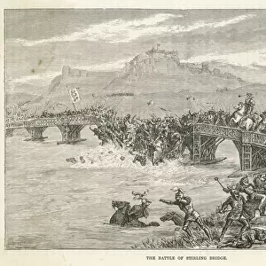
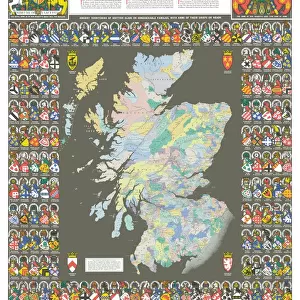
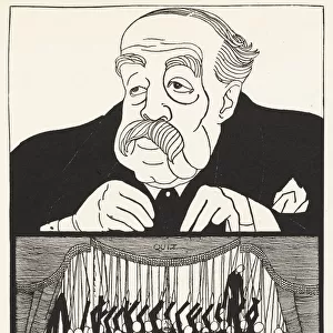
Plan of Flodden Field, Battle of Flodden, Northumberland, between England and Scotland

![]()
Wall Art and Photo Gifts from Mary Evans Picture Library
Plan of Flodden Field, Battle of Flodden, Northumberland, between England and Scotland
Plan of Flodden Field, Battle of Flodden, Northumberland, between England and Scotland, 9 September 1513, part of the War of the League of Cambrai (1508-1516). Date: 1513
Mary Evans Picture Library makes available wonderful images created for people to enjoy over the centuries
Media ID 23462912
© Mary Evans Picture Library
1510s 1513 Battlefield Cambrai Flodden Layout League Northumberland Plan Scots
FEATURES IN THESE COLLECTIONS
> Europe
> United Kingdom
> England
> Maps
> Europe
> United Kingdom
> England
> Northumberland
> Related Images
> Europe
> United Kingdom
> England
> Posters
> Europe
> United Kingdom
> England
> Related Images
> Europe
> United Kingdom
> Scotland
> Maps
> Europe
> United Kingdom
> Scotland
> Posters
> Europe
> United Kingdom
> Scotland
> Related Images
> Historic
> Battles
> Related Images
> Maps and Charts
> Early Maps
> Maps and Charts
> Related Images
> Mary Evans Prints Online
> New Images August 2021
EDITORS COMMENTS
This evocative plan of Flodden Field, dating from the early 16th century, provides a hauntingly detailed record of the Battle of Flodden, which took place on September 9, 1513, in Northumberland, England. The battle was a significant engagement in the War of the League of Cambrai (1508-1516) between England and Scotland. The meticulously drawn map reveals the strategic layout of the battlefield, with the English army, led by King Henry VIII, encamped to the south, and the Scottish forces, under the command of King James IV, to the north. The River Coquet, which runs through the center of the map, marked the boundary between the two territories and may have played a role in the battle's outcome. The English army, outnumbered but determined, launched a successful surprise attack on the Scottish forces, resulting in a devastating defeat for the Scots. The Battle of Flodden is estimated to have claimed the lives of between 10,000 and 20,000 men, making it one of the bloodiest battles in British history. The map also includes the names of key geographical features, such as the villages of Branxton and Wooler, as well as the location of the English and Scottish camps. The intricate detail and accuracy of the map suggest that it was created from firsthand knowledge of the battlefield, making it an invaluable historical resource. The Battle of Flodden had far-reaching consequences, including the consolidation of English power in the north and the end of Scottish independence for over a century. This poignant map serves as a poignant reminder of the human cost of war and the enduring power of historical records to bring the past to life.
MADE IN THE USA
Safe Shipping with 30 Day Money Back Guarantee
FREE PERSONALISATION*
We are proud to offer a range of customisation features including Personalised Captions, Color Filters and Picture Zoom Tools
SECURE PAYMENTS
We happily accept a wide range of payment options so you can pay for the things you need in the way that is most convenient for you
* Options may vary by product and licensing agreement. Zoomed Pictures can be adjusted in the Cart.