Home > North America > United States of America > Louisiana > New Orleans
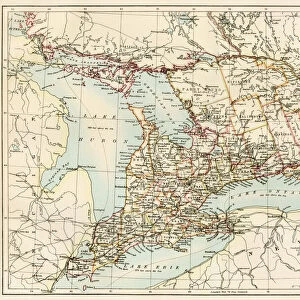
Map of Washington to New Orleans

![]()
Wall Art and Photo Gifts from Mary Evans Picture Library
Map of Washington to New Orleans
Proposed road between Washington and New Orleans, c1830 through Virginia, Kentucky, North and South Carolina, Georgia, Tennessee, Mississippi, Alabama and Louisiana states Date: c. 1830
Mary Evans Picture Library makes available wonderful images created for people to enjoy over the centuries
Media ID 7404419
© Mary Evans Picture Library 2015 - https://copyrighthub.org/s0/hub1/creation/maryevans/MaryEvansPictureID/10474563
FEATURES IN THESE COLLECTIONS
> Asia
> Georgia
> Related Images
> Maps and Charts
> Related Images
> Mary Evans Prints Online
> National Archives
> North America
> Related Images
> North America
> United States of America
> Louisiana
> New Orleans
> South America
> Related Images
EDITORS COMMENTS
This map print, dated around 1830, illustrates a proposed road route connecting Washington, D.C. to New Orleans, traversing through the eastern United States. The map showcases the developing infrastructure of the young nation during the 19th century, highlighting the growth and expansion of the American road system. The journey begins in the nation's capital, Washington D.C., and passes through the picturesque landscapes of Virginia, Kentucky, and Tennessee. As the road progresses southward, it cuts through the heart of the Carolinas, revealing the intricate network of rivers and waterways that crisscrossed the region. The map then enters the vibrant and diverse states of Georgia, Alabama, and Mississippi, where the road winds its way through the rolling hills and fertile plains. The final leg of the journey takes travelers through the lush bayous and plantation-dotted landscape of Louisiana, culminating in the bustling port city of New Orleans. This map not only serves as a testament to the ingenuity and ambition of the American people during the 19th century but also offers a fascinating glimpse into the geography and topography of the eastern United States during a pivotal time in its history. The intricate details and meticulous labeling make this map a valuable historical artifact and an essential addition to any collection of Americana or cartography.
MADE IN THE USA
Safe Shipping with 30 Day Money Back Guarantee
FREE PERSONALISATION*
We are proud to offer a range of customisation features including Personalised Captions, Color Filters and Picture Zoom Tools
SECURE PAYMENTS
We happily accept a wide range of payment options so you can pay for the things you need in the way that is most convenient for you
* Options may vary by product and licensing agreement. Zoomed Pictures can be adjusted in the Cart.