Home > Europe > United Kingdom > England > London > Fire Brigade
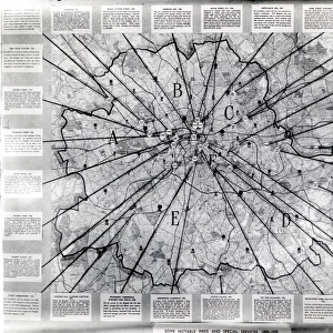
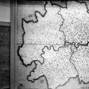
Area map for the National Fire Service in London, WW2

![]()
Wall Art and Photo Gifts from Mary Evans Picture Library
Area map for the National Fire Service in London, WW2
Area map for the National Fire Service in London
Mary Evans Picture Library makes available wonderful images created for people to enjoy over the centuries
Media ID 7638303
© London Fire Brigade / Mary Evans Picture Library
1941 Area Areas Districts Divided Greater Maps Regions Sections Services Firefighter Firefighting
FEATURES IN THESE COLLECTIONS
> Europe
> United Kingdom
> England
> London
> Fire Brigade
> Maps and Charts
> World
> Mary Evans Prints Online
> London Fire Brigade
> Popular Themes
> Firefighters
EDITORS COMMENTS
This historic area map for the National Fire Service in London, dating back to the 1940s during World War II, provides a fascinating insight into the organizational structure of firefighting services in the British capital during a time of great adversity. The map is divided into greater regions, districts, and sections, each with its own unique identifier, reflecting the extensive coverage and comprehensive response capabilities of the National Fire Service. The map serves as a testament to the importance of effective communication and coordination during wartime, with clear markings indicating fire stations, fire brigades, and other key facilities such as water towers and air raid shelters. The intricate detailing of the map underscores the meticulous planning and preparation that went into ensuring the safety and security of London's residents during the war. The National Fire Service played a crucial role in protecting London from the devastating effects of the Blitz, with firefighters working tirelessly to extinguish fires caused by German air raids. This map would have been an essential tool for firefighters and commanders, enabling them to quickly and efficiently deploy resources to areas in need. The map also highlights the extensive network of fire stations and brigades that were established across London during this period, with each station identified by its unique number and location. The map's intricate detailing and clear, easy-to-read design make it an invaluable resource for anyone interested in the history of firefighting in London during World War II. This photograph is from the London Fire Brigade collection at Mary Evans Picture Library and provides a unique glimpse into the past, offering a valuable insight into the logistical challenges and operational strategies of firefighting services during wartime.
MADE IN THE USA
Safe Shipping with 30 Day Money Back Guarantee
FREE PERSONALISATION*
We are proud to offer a range of customisation features including Personalised Captions, Color Filters and Picture Zoom Tools
SECURE PAYMENTS
We happily accept a wide range of payment options so you can pay for the things you need in the way that is most convenient for you
* Options may vary by product and licensing agreement. Zoomed Pictures can be adjusted in the Cart.