Home > Maps and Charts > Willem Janszoon Blaeu
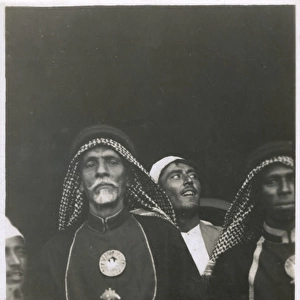
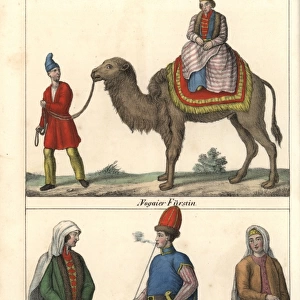
Atlas Novus. Asia. Arabian people, 17th c

![]()
Wall Art and Photo Gifts from Mary Evans Picture Library
Atlas Novus. Asia. Arabian people, 17th c
BLAEU, Jan (1596-1673). Atlas Novus or Atlas Maior. 1635 - 1665. Asia noviter delineata. Map of Asia printed in Amsterdam circa 1635. Detail depicting Arabian people. Etching. SPAIN. CATALONIA. Barcelona. Biblioteca de Catalunya (National Library of Catalonia)
Mary Evans Picture Library makes available wonderful images created for people to enjoy over the centuries
Media ID 14179470
© Iberfoto/Mary Evans
1571 1596 1635 1638 1665 1673 Amsterdam Arabian Atlas Barcelona Biblioteca Blaeu Catalonia Catalunya Delineata Depicting Engravings Etching Etchings Janszoon Maior Monde Noviter Novus Upright Willem Masculine Persons
EDITORS COMMENTS
This intricately detailed etching is a part of the Atlas Novus or Atlas Maior, a significant cartographic work created by the Flemish cartographer Jan Blaeu between 1635 and 1665. The map focuses on the Asian continent and was printed in Amsterdam during the 17th century. In this particular detail, we see a representation of Arabian people, adding a human element to the vast expanse of Asia. The image depicts a group of men, dressed in traditional garments, engaged in various activities. One man is shown playing a musical instrument, while another appears to be leading a camel. The intricate details of their clothing, accessories, and facial features reveal the meticulous attention to detail that Blaeu and his team brought to their work. The Atlas Novus was a groundbreaking work for its time, as it was one of the most accurate and comprehensive maps of Asia produced during the 17th century. It was also one of the most beautiful, with intricate engravings and vivid colors that brought the world to life. This map was produced during the height of the Dutch Golden Age, a period of great cultural and artistic achievement in the Netherlands. The map was produced in Barcelona, Spain, in the Catalonia region, at the Biblioteca de Catalunya (National Library of Catalonia). The map is vertical and upright, with the Arabian people depicted in the lower right-hand corner. The map is an important historical artifact, providing a glimpse into the world as it was perceived during the 17th century. It is also a testament to the artistic and cartographic achievements of the time, and a reminder of the rich cultural heritage of the Netherlands and Spain.
MADE IN THE USA
Safe Shipping with 30 Day Money Back Guarantee
FREE PERSONALISATION*
We are proud to offer a range of customisation features including Personalised Captions, Color Filters and Picture Zoom Tools
SECURE PAYMENTS
We happily accept a wide range of payment options so you can pay for the things you need in the way that is most convenient for you
* Options may vary by product and licensing agreement. Zoomed Pictures can be adjusted in the Cart.