Home > Maps and Charts > Willem Janszoon Blaeu
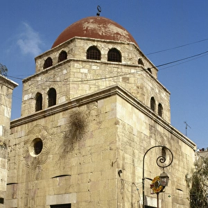
Atlas Novus. Asia, 17th c Damascus

![]()
Wall Art and Photo Gifts from Mary Evans Picture Library
Atlas Novus. Asia, 17th c Damascus
BLAEU, Jan (1596-1673). Atlas Novus or Atlas Maior. 1635 - 1665. Asia noviter delineata. Map of Asia printed in Amsterdam ca. 1635. Detail with view of the city of Damasco. Etching. SPAIN. CATALONIA. Barcelona. Biblioteca de Catalunya (National Library of Catalonia)
Mary Evans Picture Library makes available wonderful images created for people to enjoy over the centuries
Media ID 14179312
© Iberfoto/Mary Evans
1571 1596 1635 1638 1665 1673 Amsterdam Atlas Barcelona Biblioteca Blaeu Cartographic Cartographies Cartography Catalonia Catalunya Cities Damascus Delineata Engravings Etching Etchings Janszoon Maior Maps Monde Noviter Novus Rivers Willem
EDITORS COMMENTS
This detail is taken from the Atlas Novus, or Atlas Maior, a monumental and intricately detailed map of Asia created by the renowned Flemish cartographer Jan Blaeu between 1635 and 1665. Printed in Amsterdam, this map was produced during the height of the Dutch Golden Age, a period marked by significant advancements in cartography and exploration. The image showcases the city of Damasco, located in modern-day Syria, as it appeared in the 17th century. The meticulously etched lines and vibrant colors bring the urban landscape to life, revealing the city's distinct architectural features, such as the Le Theatre du Monde, a notable landmark during that era. The map also highlights various rivers, including the Willam (or William) River, which runs through the city. This map was part of a larger atlas, which was produced by Blaeu and his team in collaboration with Willem Janszoon, a Dutch cartographer. The Atlas Novus was considered a significant achievement in cartography due to its extensive coverage of Asia and its high-quality production. The map was later acquired by the Biblioteca de Catalunya (National Library of Catalonia) in Barcelona, Spain, where it remains an essential piece of cartographic history. The Atlas Novus represents a testament to the meticulous work of its creators and the advancements in cartographic techniques during the 17th century. Its intricate details and accurate representations of geographical features continue to captivate scholars and enthusiasts alike, offering a glimpse into the rich history and cultural diversity of Asia during this period.
MADE IN THE USA
Safe Shipping with 30 Day Money Back Guarantee
FREE PERSONALISATION*
We are proud to offer a range of customisation features including Personalised Captions, Color Filters and Picture Zoom Tools
SECURE PAYMENTS
We happily accept a wide range of payment options so you can pay for the things you need in the way that is most convenient for you
* Options may vary by product and licensing agreement. Zoomed Pictures can be adjusted in the Cart.