Home > Europe > United Kingdom > Scotland > Maps
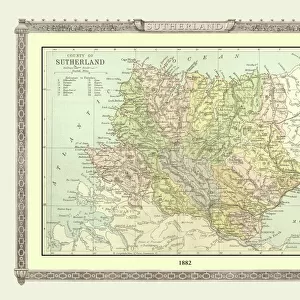
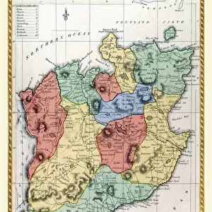
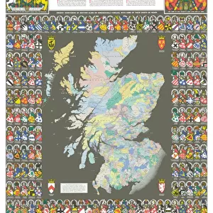
Old County Map of Sutherland Scotland 1847 by A&C Black

![]()
Wall Art and Photo Gifts from MapSeeker
Old County Map of Sutherland Scotland 1847 by A&C Black
A finely detailed facimile remastered in full colour from an antique original map of Sutherland featured in A&C Blacks Atlas of 1847. Each Parish is numbered using an index table, colour rendition beautifully differentiating all of the Parishes. As well as principal roads, towns, villages and hamlets, these county maps of Scotland feature key battle sites marked with two crossed swords and the date of the battle
Welcome to the Mapseeker Image library and enter an historic gateway to one of the largest on-line collections of Historic Maps, Nostalgic Views, Vista's and Panorama's from a World gone by.
Media ID 20347590
© Mapseeker Publishing Ltd
A And C Black A And C Black Atlas A And C Black Map County Map County Map Of Scotland Historic Map Old County Map Old Scottish County Map Scottish County Map Sutherland
FEATURES IN THESE COLLECTIONS
> Arts
> Photorealistic artworks
> Detailed art pieces
> Masterful detailing in art
> Europe
> United Kingdom
> Scotland
> Maps
> Europe
> United Kingdom
> Scotland
> Sutherland
> Maps and Charts
> Early Maps
> Maps and Charts
> Related Images
> MapSeeker
> Maps from the British Isles
> England and Counties PORTFOLIO
> MapSeeker
> Maps from the British Isles
> Scotland and Counties PORTFOLIO
EDITORS COMMENTS
Step back in time with this beautifully remastered Old County Map of Sutherland, Scotland from 1847 by A&C Black. This exquisite print captures the intricate details of an antique original map featured in A&C Blacks Atlas, allowing you to explore the historical landscape of Sutherland in full color. The map showcases each Parish numbered and easily accessible through an index table, while a stunning array of colors differentiates them with utmost precision. As you navigate through the principal roads, towns, villages, and hamlets depicted on this map, your eyes will be drawn to key battle sites marked by two crossed swords and their respective dates—a testament to Scotland's rich history. Immerse yourself in the past as you trace the borders of Sutherland and uncover its hidden gems. Discover how this historic county has evolved over time and gain a deeper understanding of its cultural heritage. Whether you're a history enthusiast or simply captivated by cartography, this old Scottish county map is sure to ignite your curiosity. With meticulous attention to detail and a touch of nostalgia woven into every inch, this authentic reproduction transports you back to 19th-century Scotland. Hang it proudly on your wall or use it as a conversation starter—this Old County Map of Sutherland is not just a piece of art but also a window into our captivating past.
MADE IN THE USA
Safe Shipping with 30 Day Money Back Guarantee
FREE PERSONALISATION*
We are proud to offer a range of customisation features including Personalised Captions, Color Filters and Picture Zoom Tools
SECURE PAYMENTS
We happily accept a wide range of payment options so you can pay for the things you need in the way that is most convenient for you
* Options may vary by product and licensing agreement. Zoomed Pictures can be adjusted in the Cart.