Home > Maps and Charts > World
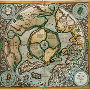
Old Map of The North Pole "Septentrionalium Terrarum descriptio"originally Published by Johannes Cloppenburg 1632

![]()
Wall Art and Photo Gifts from MapSeeker
Old Map of The North Pole "Septentrionalium Terrarum descriptio"originally Published by Johannes Cloppenburg 1632
A striking reproduction from Cloppenburgs reduced size edition of Mercators map of the North Polar regions, the first separate map of the North Polar Regions. Gerard Mercator was the first cartographer to create a polar projection of the earth. This map, the first separate map devoted to the Arctic regions, is drawn from an inset on Mercators world map of 1569. The map is extended to 60 degrees, to incorporate the recent explorations in search of the North West and North East Passages by Frobisher and Davis
Welcome to the Mapseeker Image library and enter an historic gateway to one of the largest on-line collections of Historic Maps, Nostalgic Views, Vista's and Panorama's from a World gone by.
Media ID 20347045
FEATURES IN THESE COLLECTIONS
> Maps and Charts
> Related Images
> Maps and Charts
> World
EDITORS COMMENTS
This print showcases an exquisite reproduction of the "Old Map of The North Pole" originally published by Johannes Cloppenburg in 1632. This particular version is from Cloppenburg's reduced size edition of Gerard Mercator's map, which was the first separate map ever created for the North Polar regions. Gerard Mercator, a pioneering cartographer, revolutionized mapping with his polar projection of the earth. This historic map draws upon an inset found on Mercator's world map from 1569 and extends its reach to 60 degrees. By incorporating recent explorations led by Frobisher and Davis in search of the elusive North West and North East Passages, this map offers a fascinating glimpse into early Arctic exploration. The intricate details captured in this reproduction transport us back to a time when these icy realms were shrouded in mystery and intrigue. From its delicate illustrations depicting mythical sea creatures to meticulously marked coastlines, every element on this map tells a story waiting to be discovered. As we gaze upon this remarkable piece of history, we are reminded not only of humanity's insatiable thirst for knowledge but also our relentless pursuit to conquer uncharted territories. It serves as a testament to the bravery and curiosity that drove explorers through treacherous waters and unforgiving landscapes. Whether you're an avid historian or simply captivated by ancient maps, this stunning print will undoubtedly add depth and character to any space it graces while serving as a reminder of our collective quest for
MADE IN THE USA
Safe Shipping with 30 Day Money Back Guarantee
FREE PERSONALISATION*
We are proud to offer a range of customisation features including Personalised Captions, Color Filters and Picture Zoom Tools
SECURE PAYMENTS
We happily accept a wide range of payment options so you can pay for the things you need in the way that is most convenient for you
* Options may vary by product and licensing agreement. Zoomed Pictures can be adjusted in the Cart.