Home > Europe > United Kingdom > England > London > Royalty
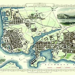
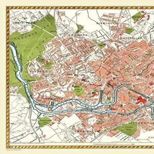
Old Map of Plymouth, Devonport and Stonehouse 1898 from the Royal Atlas by Bartholomew

![]()
Wall Art and Photo Gifts from MapSeeker
Old Map of Plymouth, Devonport and Stonehouse 1898 from the Royal Atlas by Bartholomew
A fine very detailed plan of the Port City of Plymouth with Devonport and Stonehouse, remastered from an original contained within " The Royal Atlas of England and Wales" ; edited by J.G. Bartholomew, published by George Newnes, Limited, London
Welcome to the Mapseeker Image library and enter an historic gateway to one of the largest on-line collections of Historic Maps, Nostalgic Views, Vista's and Panorama's from a World gone by.
Media ID 20347793
Bartholomew Historic Map Old Town Plan Royal Atlas Royal Atlas Map Devonport Plymouth Stonehouse
FEATURES IN THESE COLLECTIONS
> Arts
> Photorealistic artworks
> Detailed art pieces
> Masterful detailing in art
> Europe
> United Kingdom
> England
> London
> Royalty
> Europe
> United Kingdom
> England
> Maps
> Europe
> United Kingdom
> England
> Plymouth
> Europe
> United Kingdom
> Wales
> Maps
> Europe
> United Kingdom
> Wales
> Posters
> Maps and Charts
> Related Images
> Maps and Charts
> Wales
> MapSeeker
> British Town And City Plans
> English & Welsh PORTFOLIO
EDITORS COMMENTS
This beautifully preserved print showcases an exquisite piece of history - the "Old Map of Plymouth, Devonport and Stonehouse 1898" from the renowned Royal Atlas by Bartholomew. Offering a glimpse into the past, this fine and incredibly detailed plan captures the essence of these three interconnected towns in Devon, England. Remastered from an original map found within "The Royal Atlas of England and Wales" edited by J. G. Bartholomew and published by George Newnes Limited in London, this print is a true treasure for history enthusiasts. The city of Plymouth, with its bustling port and rich maritime heritage, takes center stage on this historic map. Every street, building, and landmark is meticulously depicted on this town plan. From the winding lanes to the grand architecture that adorns each corner, one can almost imagine stepping back in time to witness life as it once was in Plymouth. Devonport and Stonehouse also find their place on this remarkable map. These neighboring towns have played significant roles throughout history due to their strategic locations along the coast. Their inclusion adds depth to our understanding of how these communities were intertwined during that era. Whether you are a cartography aficionado or simply curious about Plymouth's past, this old map offers a captivating journey through time. Its intricate details provide valuable insights into urban development while evoking nostalgia for a bygone era when horse-drawn carriages traversed these streets instead of modern vehicles we see today
MADE IN THE USA
Safe Shipping with 30 Day Money Back Guarantee
FREE PERSONALISATION*
We are proud to offer a range of customisation features including Personalised Captions, Color Filters and Picture Zoom Tools
SECURE PAYMENTS
We happily accept a wide range of payment options so you can pay for the things you need in the way that is most convenient for you
* Options may vary by product and licensing agreement. Zoomed Pictures can be adjusted in the Cart.