Home > Historic > Medieval architecture > Castles and fortresses > Historic castles
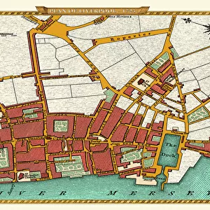
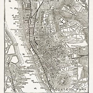
Old map of Liverpool 1650 by Thomas Kaye

![]()
Wall Art and Photo Gifts from MapSeeker
Old map of Liverpool 1650 by Thomas Kaye
An interesting map originally published in 1829 by Thomas Kaye, this reproduction map represents the town of Liverpool in 1650. Thomas made a copy from the original drawing of 1650 that was deposited in the Court of the Duchy of Lancaster as well as using other authentic and original documents. This fascinating plan shows Liverpool many years before it transformed into one of the largest and famous sea ports in the World. LiverpoolAEs long gone Castle is prominent along with other famous landmarks
Welcome to the Mapseeker Image library and enter an historic gateway to one of the largest on-line collections of Historic Maps, Nostalgic Views, Vista's and Panorama's from a World gone by.
Media ID 20346931
City Of Liverpool Map Historic Liverpool Map Historic Map Liverpool Liverpool City Liverpool City Map Liverpool Map Liverpool Town Plan Map Of Liverpool Old Map Of Liverpool Old Town Plan Town Plan Of Liverpool
FEATURES IN THESE COLLECTIONS
> Historic
> Medieval architecture
> Castles and fortresses
> Historic castles
> Historic
> Monuments and landmarks
> Historic landmarks
> Maps and Charts
> Related Images
> Maps and Charts
> World
> MapSeeker
> British Town And City Plans
> English & Welsh PORTFOLIO
EDITORS COMMENTS
This print showcases an old map of Liverpool from 1650, meticulously reproduced by Thomas Kaye in 1829. Drawing inspiration from the original drawing deposited in the Court of the Duchy of Lancaster and other authentic documents, Kaye has brought to life a remarkable representation of Liverpool's town plan during its early years. The map offers a glimpse into a time when Liverpool was yet to become one of the world's largest and most renowned seaports. Prominently featured is Liverpool's long-lost Castle, once a symbol of power and authority that now resides only in historical records. Alongside this iconic landmark, other famous points of interest are also captured on this historic map. With every intricate detail preserved, viewers can immerse themselves in the rich history that shaped this vibrant city. From narrow streets winding through bustling neighborhoods to open spaces awaiting future development, each element tells a story waiting to be discovered. Thomas Kaye's reproduction serves as both an educational tool for historians and an enchanting piece for admirers of cartography alike. It transports us back centuries ago when Liverpool was still carving its path towards greatness. As we gaze upon this fascinating snapshot frozen in time, we are reminded that even amidst progress and transformation, it is crucial to honor our roots and cherish the journey that led us here.
MADE IN THE USA
Safe Shipping with 30 Day Money Back Guarantee
FREE PERSONALISATION*
We are proud to offer a range of customisation features including Personalised Captions, Color Filters and Picture Zoom Tools
SECURE PAYMENTS
We happily accept a wide range of payment options so you can pay for the things you need in the way that is most convenient for you
* Options may vary by product and licensing agreement. Zoomed Pictures can be adjusted in the Cart.