Home > Animals > Mammals > Soricidae > Navigator
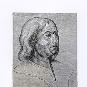
WORLD MAP, c1513. World map by Martin Waldseemuller, thought by some to have been

![]()
Wall Art and Photo Gifts from Granger
WORLD MAP, c1513. World map by Martin Waldseemuller, thought by some to have been
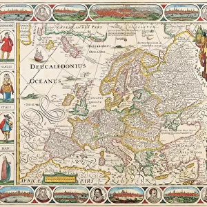
WORLD MAP, c1513.
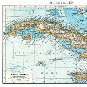
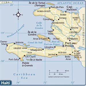
World map by Martin Waldseemuller, thought by some to have been compiled with the assistance of Christopher Columbus and so referred to as the Admirals Map, c1513. The islands of Isabella (Cuba) and Spagnolla (Hispaniola) appear at the far left, center
Granger holds millions of images spanning more than 25,000 years of world history, from before the Stone Age to the dawn of the Space Age
Media ID 12320983
1513 Admiral Age Of Discovery Christopher Columbus Cuba Haiti Isabel Martin Navigate Navigator New World North America Portolan Chart South America World Waldseemuller
FEATURES IN THESE COLLECTIONS
> Animals
> Mammals
> Soricidae
> Navigator
> Animals
> Mammals
> Vespertilionidae
> Isabella
> Arts
> Landscape paintings
> Waterfall and river artworks
> River artworks
> Granger Art on Demand
> Maps
> Maps and Charts
> World
> North America
> Cuba
> Maps
> North America
> Haiti
> Maps
> South America
> Related Images
EDITORS COMMENTS
This print showcases the remarkable "WORLD MAP, c1513" created by Martin Waldseemuller. Believed to have been compiled with the assistance of Christopher Columbus, this map is often referred to as the Admirals Map due to its potential collaboration with the renowned explorer. The map depicts a world on the brink of discovery during the Age of Exploration. At first glance, one's eyes are drawn to the islands of Isabella (Cuba) and Spagnolla (Hispaniola), prominently featured at the far left and center respectively. These islands serve as a testament to Columbus' voyages and his significant role in uncovering new lands. As we delve further into this intricate cartographic masterpiece, we witness an array of continents and rivers that were yet unknown to European navigators at that time. North America emerges in all its vastness while South America reveals itself with its majestic landscapes waiting for exploration. Waldseemuller's attention to detail is evident in every stroke, showcasing his expertise as a navigator and cartographer. The inclusion of portolan charts emphasizes his dedication towards accurate representation. This print transports us back in time when brave sailors like Christopher Columbus embarked on perilous journeys across uncharted waters, driven by their insatiable curiosity about our planet's mysteries. It serves as a reminder of humanity's relentless pursuit for knowledge and adventure during an era that forever altered our understanding of geography and shaped our modern world.
MADE IN THE USA
Safe Shipping with 30 Day Money Back Guarantee
FREE PERSONALISATION*
We are proud to offer a range of customisation features including Personalised Captions, Color Filters and Picture Zoom Tools
FREE COLORIZATION SERVICE
You can choose advanced AI Colorization for this picture at no extra charge!
SECURE PAYMENTS
We happily accept a wide range of payment options so you can pay for the things you need in the way that is most convenient for you
* Options may vary by product and licensing agreement. Zoomed Pictures can be adjusted in the Cart.