Home > Europe > United Kingdom > England > Herefordshire > Ledbury > Robert Browning
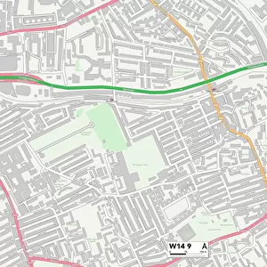
Westminster W9 1 Map

![]()
Wall Art and Photo Gifts from Map Marketing
Westminster W9 1 Map
Postcode Sector Map of Westminster W9 1
Media ID 19980904
Ashworth Road Browning Close Clarendon Gardens Clifton Gardens Clifton Road Elizabeth Close Lanark Road Randolph Road Robert Close Vale Close Warwick Avenue Westminster Maida Vale
FEATURES IN THESE COLLECTIONS
> Europe
> United Kingdom
> England
> Herefordshire
> Ledbury
> Robert Browning
> Europe
> United Kingdom
> Scotland
> Moray
> Elgin
> Europe
> United Kingdom
> Scotland
> Strathclyde
> Lanark
> Map Marketing
> Postcode Sector Maps
> W - London W
> Maps and Charts
> Related Images
MADE IN THE USA
Safe Shipping with 30 Day Money Back Guarantee
FREE PERSONALISATION*
We are proud to offer a range of customisation features including Personalised Captions, Color Filters and Picture Zoom Tools
SECURE PAYMENTS
We happily accept a wide range of payment options so you can pay for the things you need in the way that is most convenient for you
* Options may vary by product and licensing agreement. Zoomed Pictures can be adjusted in the Cart.