Home > Europe > United Kingdom > England > London > Boroughs > Wandsworth
Wandsworth SW15 3 Map

![]()
Wall Art and Photo Gifts from Map Marketing
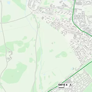
Wandsworth SW15 3 Map
Postcode Sector Map of Wandsworth SW15 3
Media ID 19982134
Beaufort Close Beaumont Road Bowling Green Close Cedar Close Colebrook Close Derwent Avenue Frensham Drive Friars Avenue Garden Close Grasmere Avenue Heath Rise Keswick Avenue Kingston Road Mere Close Paddock Way Portsmouth Road Robin Hood Lane Robin Hood Road Scott Avenue Seaton Close Stag Lane Telegraph Road Ullswater Close Ullswater Crescent Vale Crescent Wandsworth West Hill Whitefield Close Windermere Road Woodview Close A308 Putney Heath Sw15
FEATURES IN THESE COLLECTIONS
> Animals
> Mammals
> Muridae
> Heath Mouse
> Europe
> United Kingdom
> England
> London
> Boroughs
> Wandsworth
> Map Marketing
> Postcode Sector Maps
> SW - London SW
> Maps and Charts
> Related Images
MADE IN THE USA
Safe Shipping with 30 Day Money Back Guarantee
FREE PERSONALISATION*
We are proud to offer a range of customisation features including Personalised Captions, Color Filters and Picture Zoom Tools
SECURE PAYMENTS
We happily accept a wide range of payment options so you can pay for the things you need in the way that is most convenient for you
* Options may vary by product and licensing agreement. Zoomed Pictures can be adjusted in the Cart.