Home > Europe > United Kingdom > Scotland > Dumfries and Galloway > Thornhill
Southampton SO16 7 Map

![]()
Wall Art and Photo Gifts from Map Marketing
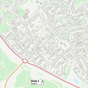
Southampton SO16 7 Map
Postcode Sector Map of Southampton SO16 7
Media ID 19981698
Ashwood Gardens Bassett Close Beaumont Close Birch Road Botley Road Copse Lane Dene Close Enterprise Road Golf Course Road Green Lane Greenbank Crescent Hadrian Way Highclere Road Holly Hill Holly Place Julian Close Manor Road Oaklands Way Pine Walk Pine Way Pinewood Redhill Redhill Close Roman Drive Roman Road Sherwood Close So16 Southampton Talbot Close The Cloisters The Firs The Mount The Orchard Thornhill Road Tower Gardens Underwood Close Underwood Road Vermont Close Winchester Road Woodside Woodside Crescent Wykeham Close
FEATURES IN THESE COLLECTIONS
> Animals
> Mammals
> Muridae
> Heath Mouse
> Animals
> Mammals
> Muridae
> Ling
> Animals
> Mammals
> Muridae
> Little Wood Mouse
> Europe
> United Kingdom
> Scotland
> Dumfries and Galloway
> Thornhill
> Map Marketing
> Postcode Sector Maps
> SO - Southampton
> Maps and Charts
> Related Images
MADE IN THE USA
Safe Shipping with 30 Day Money Back Guarantee
FREE PERSONALISATION*
We are proud to offer a range of customisation features including Personalised Captions, Color Filters and Picture Zoom Tools
SECURE PAYMENTS
We happily accept a wide range of payment options so you can pay for the things you need in the way that is most convenient for you
* Options may vary by product and licensing agreement. Zoomed Pictures can be adjusted in the Cart.