Home > Europe > United Kingdom > England > Durham > Stanley
Crawley RH10 5 Map

![]()
Wall Art and Photo Gifts from Map Marketing
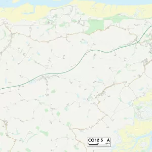
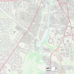
Crawley RH10 5 Map
Postcode Sector Map of Crawley RH10 5
Media ID 19976468
Ashdown Drive Barry Close Blake Close Boswell Road Canterbury Road Caxton Close Chichester Close Constable Road Cook Road Crawley Dickens Road Drake Road Durham Close Ely Close Exeter Close Gainsborough Road Gloucester Road Hanover Close Hawkins Road Hereford Close Hogarth Road Lincoln Close Livingstone Road Nash Road Oxford Road Peterborough Road Rh10 Ross Close Salisbury Road Scott Road Shackleton Road Stanley Close The Avenue Wells Road Whittington Road Winchester Road Worcester Road York Road
FEATURES IN THESE COLLECTIONS
> Animals
> Birds
> Passerines
> Whistlers
> Related Images
> Arts
> Artists
> W
> Weddell Weddell
> Europe
> United Kingdom
> England
> Durham
> Durham
> Europe
> United Kingdom
> England
> Durham
> Stanley
> Europe
> United Kingdom
> England
> Herefordshire
> Maps
> Europe
> United Kingdom
> Wales
> South Glamorgan
> Barry
> Map Marketing
> Postcode Sector Maps
> RH - Redhill
> Maps and Charts
> Related Images
MADE IN THE USA
Safe Shipping with 30 Day Money Back Guarantee
FREE PERSONALISATION*
We are proud to offer a range of customisation features including Personalised Captions, Color Filters and Picture Zoom Tools
SECURE PAYMENTS
We happily accept a wide range of payment options so you can pay for the things you need in the way that is most convenient for you
* Options may vary by product and licensing agreement. Zoomed Pictures can be adjusted in the Cart.