Home > Europe > United Kingdom > England > London > Towns > Higham Hill
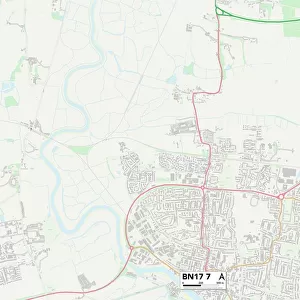
Surrey Heath GU20 6 Map

![]()
Wall Art and Photo Gifts from Map Marketing
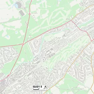
Surrey Heath GU20 6 Map
Postcode Sector Map of Surrey Heath GU20 6
Media ID 19972826
Birch Road Broadway Road Burton Close Caldwell Road Chertsey Road Church Road Cooper Road Deans Court Edward Road Graham Road Hutton Close Kennel Lane Kent Road Kings Lane Lawrence Crescent London Road Molyneux Road Moor Place New Road Newark Road Oakwood Road Oldhouse Lane Orchard Hill Owen Road Pine Grove Poplar Avenue Pound Lane Ramsay Road Rectory Lane School Lane School Road Shepherds Lane Surrey Heath Westwood Road White Hill Woodlands Lane Hollybush
FEATURES IN THESE COLLECTIONS
> Animals
> Mammals
> Muridae
> Heath Mouse
> Arts
> Artists
> C
> Edward Cooper
> Europe
> United Kingdom
> England
> Kent
> Grove
> Europe
> United Kingdom
> England
> Kent
> Higham
> Europe
> United Kingdom
> England
> Kent
> Lane End
> Europe
> United Kingdom
> England
> Kent
> The Moor
> Europe
> United Kingdom
> England
> London
> Politics
> Edward Heath
> Europe
> United Kingdom
> England
> London
> Towns
> Church End
> Europe
> United Kingdom
> England
> London
> Towns
> Hatton
> Europe
> United Kingdom
> England
> London
> Towns
> Higham Hill
> Map Marketing
> Postcode Sector Maps
> GU - Guildford
MADE IN THE USA
Safe Shipping with 30 Day Money Back Guarantee
FREE PERSONALISATION*
We are proud to offer a range of customisation features including Personalised Captions, Color Filters and Picture Zoom Tools
SECURE PAYMENTS
We happily accept a wide range of payment options so you can pay for the things you need in the way that is most convenient for you
* Options may vary by product and licensing agreement. Zoomed Pictures can be adjusted in the Cart.