Home > Arts > Artists > P > Gordon Parks
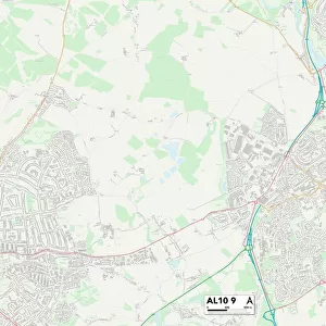
St Albans AL1 5 Map

![]()
Wall Art and Photo Gifts from Map Marketing
St Albans AL1 5 Map
Postcode Sector Map of St Albans AL1 5
Media ID 19965140
Admirals Walk Albion Road Anson Close Ashley Road Bakers Close Benbow Close Beresford Road Blake Close Burleigh Road Burnside Buttermere Close Cambridge Road Camp Road Castle Road Cavendish Road Cecil Road College Road Dexter Close Edward Close Ely Road Ennerdale Close Frobisher Road Gordon Close Granville Road Grasmere Road Grimston Road Guildford Road Haig Close Hatfield Road Howard Close Keswick Close Linden Crescent Lynton Avenue Magnolia Gardens Maxwell Road Mountbatten Close Nelson Avenue Olive Close Oxford Avenue Park View Close Ramsey Close Redwood Close Royston Road Shirley Road Springfield Road St Albans Stanhope Road Station Way Sutton Road Swallow Lane Thirlmere Drive Wellington Road Willow Crescent Windermere Avenue Aldwick
FEATURES IN THESE COLLECTIONS
> Animals
> Fishes
> S
> Swallower
> Arts
> Artists
> P
> Gordon Parks
> Map Marketing
> Postcode Sector Maps
> AL - St Albans
> Maps and Charts
> Related Images
MADE IN THE USA
Safe Shipping with 30 Day Money Back Guarantee
FREE PERSONALISATION*
We are proud to offer a range of customisation features including Personalised Captions, Color Filters and Picture Zoom Tools
SECURE PAYMENTS
We happily accept a wide range of payment options so you can pay for the things you need in the way that is most convenient for you
* Options may vary by product and licensing agreement. Zoomed Pictures can be adjusted in the Cart.