Home > North America > United States of America > New York > New York > Maps
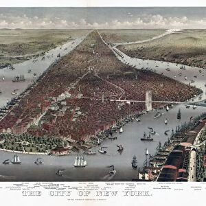
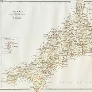
1868, Rogers Map of Manhattan, New York City, North of 86th St, topography, cartography

![]()
Wall Art and Photo Gifts from Liszt Collection
1868, Rogers Map of Manhattan, New York City, North of 86th St, topography, cartography
1868, Rogers Map of Manhattan, New York City, North of 86th St
Liszt Collection of nineteenth-century engravings and images to browse and enjoy
Media ID 14006206
© Artokoloro Quint Lox Limited
1868 New York City Antique Map Atlas Chart Geographic Latitude Longitude Mappa Mundi Old Antique Plan Old Antique View Old Map Ols Antique Map Rare Old Maps Topo
FEATURES IN THESE COLLECTIONS
> Maps and Charts
> Early Maps
> Maps and Charts
> World
> North America
> United States of America
> New York
> New York
> Manhattan
> Related Images
> North America
> United States of America
> New York
> New York
> Maps
EDITORS COMMENTS
This print showcases the intricate details of the 1868 Rogers Map of Manhattan, New York City, specifically focusing on the area north of 86th Street. A true masterpiece in cartography and topography, this vintage map takes us back to a bygone era when exploration and discovery were at their peak. The map's exquisite illustration highlights the geographic features, land formations, and even includes latitude and longitude grids for precise navigation. Its aged appearance adds a touch of historical charm, making it an ideal decorative piece for any space. As we delve into this rare antique map, we are transported to a time when Manhattan was still evolving. It offers us a glimpse into how the city looked before its modern-day skyline emerged. This fascinating mappa mundi allows us to trace our roots and understand how our world has transformed over time. Whether you're an avid traveler or history enthusiast, this old antique plan is sure to captivate your imagination. With its rich earthy tones and meticulous attention to detail, it serves as both a work of art and an invaluable historical artifact.
MADE IN THE USA
Safe Shipping with 30 Day Money Back Guarantee
FREE PERSONALISATION*
We are proud to offer a range of customisation features including Personalised Captions, Color Filters and Picture Zoom Tools
SECURE PAYMENTS
We happily accept a wide range of payment options so you can pay for the things you need in the way that is most convenient for you
* Options may vary by product and licensing agreement. Zoomed Pictures can be adjusted in the Cart.