Home > Maps and Charts > World
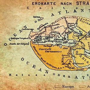
1785, Cook, Bligh Map of Hawaii, topography, cartography, geography, land, illustration

![]()
Wall Art and Photo Gifts from Liszt Collection
1785, Cook, Bligh Map of Hawaii, topography, cartography, geography, land, illustration
1785, Cook, Bligh Map of Hawaii
Liszt Collection of nineteenth-century engravings and images to browse and enjoy
Media ID 14006908
© Artokoloro Quint Lox Limited
1785 Cook Antique Map Atlas Chart Geographic Latitude Longitude Mappa Mundi Old Antique Plan Old Antique View Old Map Ols Antique Map Rare Old Maps Topo
FEATURES IN THESE COLLECTIONS
> Maps and Charts
> Early Maps
> Maps and Charts
> World
EDITORS COMMENTS
This print showcases the intricate details of a historical map from 1785, known as the Cook-Bligh Map of Hawaii. A true masterpiece in cartography, this topographical illustration offers a glimpse into the geography and land formations of this enchanting archipelago. The meticulously drawn lines depict latitude and longitude coordinates, creating a precise grid that aids in navigation across these Pacific islands. With its vintage charm and ancient allure, this old map takes us on a journey through time, allowing us to explore the world as it was centuries ago. Its decorative elements and artistic flair make it not only an invaluable tool for exploration but also a work of art in itself. As we gaze upon this rare antique map, we are reminded of the historic voyages undertaken by explorers like Captain James Cook and William Bligh. Their discoveries shaped our understanding of the region's geographical features and paved the way for future expeditions. The Liszt Collection has preserved this remarkable piece of history with utmost care, ensuring that its beauty continues to inspire generations to come. Whether you're an avid traveler or simply fascinated by ancient maps, this print is sure to ignite your sense of adventure while adding a touch of elegance to any space.
MADE IN THE USA
Safe Shipping with 30 Day Money Back Guarantee
FREE PERSONALISATION*
We are proud to offer a range of customisation features including Personalised Captions, Color Filters and Picture Zoom Tools
SECURE PAYMENTS
We happily accept a wide range of payment options so you can pay for the things you need in the way that is most convenient for you
* Options may vary by product and licensing agreement. Zoomed Pictures can be adjusted in the Cart.