Home > Maps and Charts > World
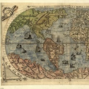
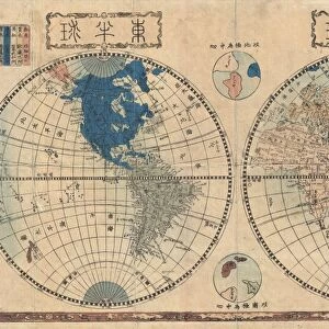
1730, Stoopendaal Map of the World in two Hemispheres, topography, cartography, geography

![]()
Wall Art and Photo Gifts from Liszt Collection
1730, Stoopendaal Map of the World in two Hemispheres, topography, cartography, geography
1730, Stoopendaal Map of the World in two Hemispheres
Liszt Collection of nineteenth-century engravings and images to browse and enjoy
Media ID 14006600
© Artokoloro Quint Lox Limited
1730 Antique Map Atlas Chart Geographic Latitude Longitude Mappa Mundi Old Antique Plan Old Antique View Old Map Ols Antique Map Rare Old Maps Topo
FEATURES IN THESE COLLECTIONS
> Maps and Charts
> Early Maps
> Maps and Charts
> World
EDITORS COMMENTS
This print showcases the exquisite "1730, Stoopendaal Map of the World in two Hemispheres". A true masterpiece of topography, cartography, and geography, this vintage map takes us on a journey through time. Its intricate details and precise illustrations depict the Earth's landforms with remarkable accuracy. As we gaze upon this ancient relic, we are transported back to an era when exploration and discovery were at their peak. The carefully plotted grid lines of latitude and longitude guide our eyes across continents and oceans, inviting us to explore every corner of our planet. The artistic elements incorporated into this historical piece add a touch of elegance and charm. The aged paper texture evokes a sense of nostalgia while reminding us of the countless hands that have held it over centuries past. With its decorative borders framing each hemisphere, this map becomes more than just a tool for navigation; it transforms into a work of art. It serves as a reminder that maps not only provide geographical information but also tell stories about human curiosity and the desire to understand our world. This rare gem from the Liszt Collection is not merely an antique map but rather an invaluable window into history itself. It allows us to marvel at how far we have come in terms of geographic knowledge while appreciating the beauty inherent in early cartographic endeavors.
MADE IN THE USA
Safe Shipping with 30 Day Money Back Guarantee
FREE PERSONALISATION*
We are proud to offer a range of customisation features including Personalised Captions, Color Filters and Picture Zoom Tools
SECURE PAYMENTS
We happily accept a wide range of payment options so you can pay for the things you need in the way that is most convenient for you
* Options may vary by product and licensing agreement. Zoomed Pictures can be adjusted in the Cart.