Home > Europe > United Kingdom > England > Maps
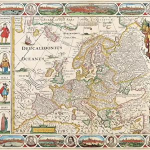
1716, Homann Map of New England Nova Anglia, topography, cartography, geography, land

![]()
Wall Art and Photo Gifts from Liszt Collection
1716, Homann Map of New England Nova Anglia, topography, cartography, geography, land
1716, Homann Map of New England Nova Anglia
Liszt Collection of nineteenth-century engravings and images to browse and enjoy
Media ID 14004495
© Artokoloro Quint Lox Limited
1716 Antique Map Atlas Chart Geographic Latitude Longitude Mappa Mundi Old Antique Plan Old Antique View Old Map Ols Antique Map Rare Old Maps Topo
FEATURES IN THESE COLLECTIONS
> Europe
> United Kingdom
> England
> Maps
> Maps and Charts
> Early Maps
> Maps and Charts
> World
EDITORS COMMENTS
This print showcases the remarkable 1716 Homann Map of New England Nova Anglia, a true masterpiece in the world of cartography. With its intricate topography and detailed geographical features, this vintage map takes us back to a bygone era when exploration and discovery were at their peak. The artistry displayed in this ancient map is truly awe-inspiring. Every line, curve, and contour has been meticulously drawn to depict the land's natural beauty. The carefully marked grid of latitude and longitude guides our imagination as we envision early travelers navigating through these uncharted territories. As we gaze upon this historical artifact, we are transported to a time when maps were not just tools for navigation but also works of art. Its aged appearance adds an extra layer of charm and authenticity, reminding us that it carries with it centuries worth of history. This rare gem from the past serves as a window into an era where knowledge was limited yet curiosity boundless. It invites us on a journey through time, allowing us to explore the region's rich heritage and understand how it has evolved over centuries. Whether you are an avid collector or simply appreciate the beauty of old maps, this Homann Map print is sure to captivate your senses with its timeless appeal.
MADE IN THE USA
Safe Shipping with 30 Day Money Back Guarantee
FREE PERSONALISATION*
We are proud to offer a range of customisation features including Personalised Captions, Color Filters and Picture Zoom Tools
SECURE PAYMENTS
We happily accept a wide range of payment options so you can pay for the things you need in the way that is most convenient for you
* Options may vary by product and licensing agreement. Zoomed Pictures can be adjusted in the Cart.