Home > Europe > Italy > Sicily > Messina
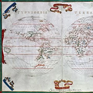
Nautical chart of the Mediterranean Sea, 1508

![]()
Wall Art and Photo Gifts from Heritage Images
Nautical chart of the Mediterranean Sea, 1508
Nautical chart of the Mediterranean Sea, 1508. Found in the collection of Museo Maritimo, Barcelona
Heritage Images features heritage image collections
Media ID 15043360
© Fine Art Images
Cartography Chart Nautical Chart Portolan Portolan Chart Watercolour On Parchment Italiy Russo
FEATURES IN THESE COLLECTIONS
> Europe
> Italy
> Sicily
> Messina
EDITORS COMMENTS
This print showcases a remarkable piece of history - a nautical chart of the Mediterranean Sea from the year 1508. Housed within the prestigious collection of Museo Maritimo in Barcelona, this map is an exquisite example of cartography and graphic arts from the early 16th century. Created using watercolor on parchment, it belongs to the renowned Italian school of Messina and was crafted by Pietro Russo. The intricacy and attention to detail in this portolan chart are truly awe-inspiring. Every coastline, island, and navigational landmark is meticulously depicted with precision and accuracy. This ancient map served as an indispensable tool for sailors during that era, guiding them through treacherous waters while ensuring safe passage along trade routes. As we gaze upon this fine art image today, we are transported back in time to an era when exploration and maritime adventures were at their peak. The vibrant colors used by Russo bring life to the sea, evoking a sense of wonderment for those who study it closely. This photograph not only captures a significant historical artifact but also serves as a testament to human ingenuity and our relentless pursuit of knowledge. It reminds us that even centuries ago, people possessed extraordinary skills in mapping out vast territories with astonishing accuracy. With its rich history and undeniable beauty, this nautical chart stands as both a work of art and an invaluable historical document – preserving our connection to seafaring traditions that have shaped civilizations throughout time.
MADE IN THE USA
Safe Shipping with 30 Day Money Back Guarantee
FREE PERSONALISATION*
We are proud to offer a range of customisation features including Personalised Captions, Color Filters and Picture Zoom Tools
SECURE PAYMENTS
We happily accept a wide range of payment options so you can pay for the things you need in the way that is most convenient for you
* Options may vary by product and licensing agreement. Zoomed Pictures can be adjusted in the Cart.