Home > Europe > United Kingdom > Scotland > Edinburgh > Edinburgh
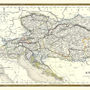
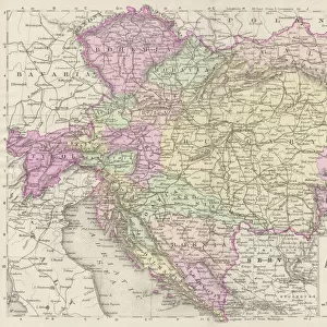
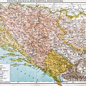
Map of Austria-Hungary, 1902. Creator: Unknown

![]()
Wall Art and Photo Gifts from Heritage Images
Map of Austria-Hungary, 1902. Creator: Unknown
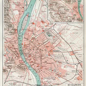
Map of Austria-Hungary, 1902. The Austro-Hungarian Empire including Bosnia, Transylvania, Bohemia, Dalmatia, Silesia, with inset of Vienna. From The Century Atlas of the World. [John Walker & Co, Ltd. London, 1902]
Heritage Images features heritage image collections
Media ID 15512796
© The Print Collector / Heritage-Images
Austria Hungary Austro Hungarian Austro Hungarian Empire Bohemia Bosnia Dalmatia Edinburgh Geographical Institute Schlesien Silesia Transylvania
FEATURES IN THESE COLLECTIONS
> Europe
> Bosnia and Herzegovina
> Maps
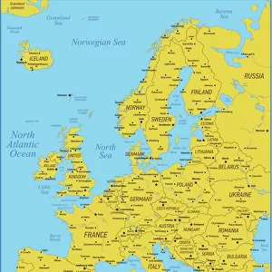
> Europe
> United Kingdom
> England
> London
> Related Images
> Europe
> United Kingdom
> Scotland
> Edinburgh
> Edinburgh
> Europe
> United Kingdom
> Scotland
> Lothian
> Edinburgh
Map of Austria-Hungary, 1902 - A Glimpse into the Vast Austro-Hungarian Empire
EDITORS COMMENTS
. This print showcases a historical gem - a meticulously detailed map of Austria-Hungary from the year 1902. With its vibrant colors and intricate design, this map offers a fascinating glimpse into the vast territories encompassed by the Austro-Hungarian Empire during that era. The empire's borders stretch far and wide, incorporating regions such as Bosnia, Transylvania, Bohemia, Dalmatia, and Silesia. The inclusion of an inset highlighting Vienna further emphasizes the significance of this imperial capital within the grandeur of Austria-Hungary. Created by an unknown cartographer or artist in collaboration with John Walker & Co. , Ltd. , London in 1902 for 'The Century Atlas of the World, ' this piece is not only visually stunning but also historically significant. It provides valuable insights into the geography and location of various provinces within this powerful empire. Commissioned during a time when color printing was still relatively rare, this print stands as a testament to both technical skill and artistic vision. Preserved over time by The Print Collector and now made available through Heritage Images, it allows us to appreciate how maps served as vital tools for understanding political boundaries and territorial expansions in early 20th-century Europe. Whether you are an avid history enthusiast or simply intrigued by cartography's beauty, this extraordinary image transports you back to a pivotal moment in European history
MADE IN THE USA
Safe Shipping with 30 Day Money Back Guarantee
FREE PERSONALISATION*
We are proud to offer a range of customisation features including Personalised Captions, Color Filters and Picture Zoom Tools
SECURE PAYMENTS
We happily accept a wide range of payment options so you can pay for the things you need in the way that is most convenient for you
* Options may vary by product and licensing agreement. Zoomed Pictures can be adjusted in the Cart.