Home > Arts > Art Movements > Medieval Art
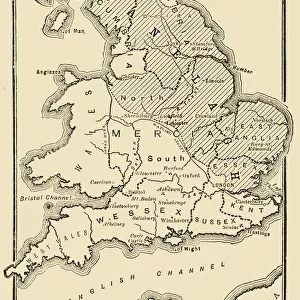
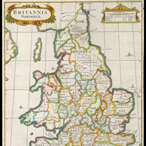
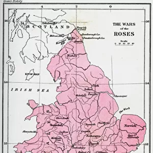
The dominions of the Angevins, 1892

![]()
Wall Art and Photo Gifts from Heritage Images
The dominions of the Angevins, 1892
The dominions of the Angevins, 1892. The territiories ruled by Henry II of England and his successors, Richard I and John. An illustration from A Short History of the English People, by John Richard Green, illustrated edition, Volume I, Macmillan and Co, London, New York, 1892
Heritage Images features heritage image collections
Media ID 14918742
© The Print Collector / Heritage-Images
Angevin Anjou Burgundy Cartography Dominion Fitzempress Henry Ii Henry Ii Curtmantle Ireland John Richard John Richard Green King Henry Ii King Of England King Of England Lionheart King Richard I Kingdom Map Making Richard I Richard L Territory Wales Thirteenth Century
FEATURES IN THESE COLLECTIONS
> Arts
> Art Movements
> Medieval Art
> Arts
> Artists
> S
> Richard Short
> Europe
> Republic of Ireland
> Maps
> Europe
> United Kingdom
> England
> Maps
> Europe
> United Kingdom
> England
> York
> Europe
> United Kingdom
> Scotland
> Maps
> Europe
> United Kingdom
> Scotland
> Posters
> Europe
> United Kingdom
> Scotland
> Related Images
> Europe
> United Kingdom
> Wales
> Maps
EDITORS COMMENTS
This print showcases "The dominions of the Angevins, 1892" a historical map depicting the territories ruled by Henry II of England and his successors, Richard I and John. The intricate illustration is taken from A Short History of the English People, Volume I, written by John Richard Green and published in 1892. In vibrant colors, this map transports us back to the 12th and 13th centuries when England was under the reign of these influential monarchs. It beautifully captures their dominion over not only England but also Ireland, Scotland, Wales, France (including Burgundy), and other medieval territories. The level of detail in this cartographic masterpiece is truly remarkable. Every country is clearly delineated with distinct borders while still maintaining an air of artistic flair. This visual representation allows us to appreciate how vast and far-reaching the influence of these Angevin kings was during their time. As we gaze upon this piece created by an unknown artist but preserved for posterity by The Print Collector6, we are reminded of King Henry II's legacy as a powerful ruler who laid down the foundations for future generations. We cannot overlook King Richard I's lionhearted spirit that left an indelible mark on history or King John's controversial reign that shaped England's destiny. This print serves as both a historical artifact and a testament to human ingenuity in map-making during the Middle Ages. Its presence invites us to explore our past through its vivid colors and intricate details –
MADE IN THE USA
Safe Shipping with 30 Day Money Back Guarantee
FREE PERSONALISATION*
We are proud to offer a range of customisation features including Personalised Captions, Color Filters and Picture Zoom Tools
SECURE PAYMENTS
We happily accept a wide range of payment options so you can pay for the things you need in the way that is most convenient for you
* Options may vary by product and licensing agreement. Zoomed Pictures can be adjusted in the Cart.