Home > Europe > United Kingdom > England > London > Museums > British Library
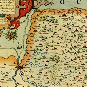
Cartouche by A. Ryther on Saxtons Map of Durham, 1576, (1944). Creator: Augustine Ryther
. Creator: Augustine Ryther")
![]()
Wall Art and Photo Gifts from Heritage Images
Cartouche by A. Ryther on Saxtons Map of Durham, 1576, (1944). Creator: Augustine Ryther
Cartouche by A. Ryther on Saxtons Map of Durham, 1576, (1944). Detail on a map the county of Durham, (the Latin word Dunelmensis means of or from Durham). One of 35 coloured maps in " Atlas of the Counties of England and Wales", the first atlas of any country, made by Christopher Saxton. Manuscript in the British Library in London. From " British Maps and Map-Makers", by Edward Lynam. [Collins, London, 1944]
Heritage Images features heritage image collections
Media ID 19777402
© The Print Collector/Heritage Images
Augustine Britain In Pictures Cartouche Christopher Collins County Durham Edward Edward Lynam Elizabethan Inscribed Inscription Latin Lynam Social History William Collins William Collins And Sons William Collins Sons Christopher Saxton Flowered Ryther Saxton
FEATURES IN THESE COLLECTIONS
> Arts
> Artists
> C
> William Collins
> Arts
> Artists
> S
> Christopher Saxton
> Europe
> United Kingdom
> England
> Durham
> Durham
> Europe
> United Kingdom
> England
> London
> Museums
> British Library
> Europe
> United Kingdom
> England
> Maps
> Europe
> United Kingdom
> Wales
> Maps
EDITORS COMMENTS
This print showcases a detailed cartouche created by Augustine Ryther on Saxtons Map of Durham in 1576. The map, featured in the renowned "Atlas of the Counties of England and Wales" was an extraordinary achievement as it marked the first atlas ever made for any country. Preserved in the British Library, this manuscript holds immense historical significance. The cartouche beautifully adorns the map with its vibrant colors and intricate design. It depicts the county of Durham, known as Dunelmensis in Latin, emphasizing its importance and origin. The floral motifs within the cartouche add a touch of elegance to this sixteenth-century masterpiece. Dating back to 1944, when this print was captured for Edward Lynam's book "British Maps and Map-Makers" it offers us a glimpse into both ancient history and mid-twentieth century Britain. This decade saw great social changes taking place alongside World War II. Through this image, we can appreciate not only Christopher Saxton's pioneering work but also the talent of Augustine Ryther who contributed to making these maps visually appealing and informative. The collaboration between these two individuals has left an indelible mark on British cartography. As we delve into this photograph from Heritage Images' collection, let us marvel at how artistry intertwines with geography to create a lasting testament to our past.
MADE IN THE USA
Safe Shipping with 30 Day Money Back Guarantee
FREE PERSONALISATION*
We are proud to offer a range of customisation features including Personalised Captions, Color Filters and Picture Zoom Tools
SECURE PAYMENTS
We happily accept a wide range of payment options so you can pay for the things you need in the way that is most convenient for you
* Options may vary by product and licensing agreement. Zoomed Pictures can be adjusted in the Cart.