Home > Arts > Artists > C > William Caxton
The Carpathian Passes, 1919. Creator: Unknown

![]()
Wall Art and Photo Gifts from Heritage Images
The Carpathian Passes, 1919. Creator: Unknown
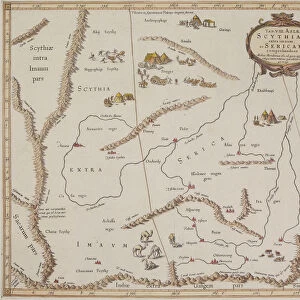
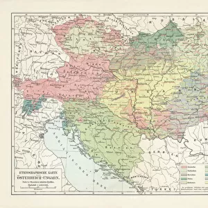
The Carpathian Passes, 1919. Map showing mountain passes in the Carpathians, a mountain range which stretches from present-day Czech Republic, through Slovakia, Poland, Hungary, Ukraine, Serbia and Romania. From " The History of the Great European War: its causes and effects", Vol. IV, by W. Stanley Macbean Knight. [Caxton Pulishing Company, Limited, London, 1919]
Heritage Images features heritage image collections
Media ID 19047607
© The Print Collector/Heritage Images
Budapest Carpathians Caxton Publishing Company Caxton Pulishing Company Caxton Pulishing Company Lim Caxton Pulishing Company Limited Caxton Pulishing Company Ltd Cracow Hungary Knight Krakow Limited Mountain Pass Mountain Range Poland Romania Stanley Macbean Stanley Macbean Knight Transylvania W Stanley Macbean W Stanley Macbean Knight William Stanley Macbean William Stanley Macbean Knight
FEATURES IN THESE COLLECTIONS
> Arts
> Artists
> C
> William Caxton
> Arts
> Artists
> D
> William Day
> Europe
> Czech Republic
> Maps
> Europe
> Czech Republic
> Posters
> Europe
> Czech Republic
> Railways
> Europe
> Czech Republic
> Related Images
> Europe
> Hungary
> Heritage Sites
> Budapest, including the Banks of
EDITORS COMMENTS
This photo print, titled "The Carpathian Passes, 1919" takes us back to the tumultuous era of the First World War. Created by an unknown artist, this map showcases the intricate network of mountain passes in the Carpathians, a majestic range spanning several countries including present-day Czech Republic, Slovakia, Poland, Hungary, Ukraine, Serbia and Romania. Extracted from W. Stanley Macbean Knight's renowned book "The History of the Great European War: its causes and effects" this print offers a glimpse into the geographical features that played a crucial role during this significant period in history. The vibrant colors bring life to each pass as they wind through rugged terrains and connect various regions. As we explore this map further, our eyes are drawn to Budapest in Hungary and Krakow in Poland – two key cities nestled within these mountains. The presence of railways indicates their importance for transportation during wartime. Transylvania looms on one side of the Carpathians—a region steeped in folklore and mystery—adding an air of intrigue to this already captivating image. It serves as a reminder that war not only reshapes borders but also impacts cultural landscapes. Preserved by The Print Collector and shared by Heritage Images today, this remarkable piece allows us to appreciate both its historical significance and artistic beauty. Let it transport us back to a time when nations clashed amidst breathtaking natural surroundings—the echoes of which still resonate with us today.
MADE IN THE USA
Safe Shipping with 30 Day Money Back Guarantee
FREE PERSONALISATION*
We are proud to offer a range of customisation features including Personalised Captions, Color Filters and Picture Zoom Tools
SECURE PAYMENTS
We happily accept a wide range of payment options so you can pay for the things you need in the way that is most convenient for you
* Options may vary by product and licensing agreement. Zoomed Pictures can be adjusted in the Cart.