Home > Europe > United Kingdom > England > Maps
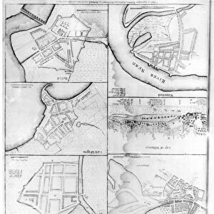
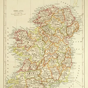
Plan of a French invasion of England and Ireland. Extract of a letter, dated London, 16 April 1798, and a map of the supposed planned invasion, printed in a contemporary broadside published in Philadelphia

![]()
Wall Art and Photo Gifts from Granger
Plan of a French invasion of England and Ireland. Extract of a letter, dated London, 16 April 1798, and a map of the supposed planned invasion, printed in a contemporary broadside published in Philadelphia
FRENCH INVASION, 1798.
Plan of a French invasion of England and Ireland. Extract of a letter, dated London, 16 April 1798, and a map of the supposed planned invasion, printed in a contemporary broadside published in Philadelphia
Granger holds millions of images spanning more than 25,000 years of world history, from before the Stone Age to the dawn of the Space Age
Media ID 10409218
1798 Antique April Artifact Broadside English Channel Invasion Ireland Napoleonic Napoleonic War Plan
FEATURES IN THESE COLLECTIONS
> Arts
> Contemporary art
> Arts
> Pop art
> Contemporary art
> Contemporary art gallery
> Europe
> Republic of Ireland
> Maps
> Europe
> United Kingdom
> England
> London
> Related Images
> Europe
> United Kingdom
> England
> Maps
> Granger Art on Demand
> Plans and Diagrams
EDITORS COMMENTS
This print showcases a historical artifact that takes us back to the turbulent times of the late 18th century. The image features a plan of a French invasion of England and Ireland, accompanied by an extract from a letter dated April 16,1798, all beautifully printed on a contemporary broadside published in Philadelphia. The intricate drawing depicts the supposed planned invasion with meticulous detail. It highlights key strategic points such as the English Channel and various locations in both England and Ireland. This map provides insight into the military tactics employed during the Napoleonic War era. As we delve deeper into this antique piece, we are transported to an era filled with political tension and conflict. The text accompanying the map adds another layer of intrigue, offering snippets of information about this audacious plan for conquest. This print is not just an artistic representation but also serves as a valuable historical document from Granger Art on Demand's Carousel Collection. It allows us to reflect upon significant events that shaped nations and altered history forever. Immerse yourself in this fascinating artifact that captures one moment in time when France contemplated invading its neighboring islands across the English Channel. Let your imagination wander as you explore this relic from centuries past, appreciating its significance within the broader context of European warfare during the Napoleonic era.
MADE IN THE USA
Safe Shipping with 30 Day Money Back Guarantee
FREE PERSONALISATION*
We are proud to offer a range of customisation features including Personalised Captions, Color Filters and Picture Zoom Tools
FREE COLORIZATION SERVICE
You can choose advanced AI Colorization for this picture at no extra charge!
SECURE PAYMENTS
We happily accept a wide range of payment options so you can pay for the things you need in the way that is most convenient for you
* Options may vary by product and licensing agreement. Zoomed Pictures can be adjusted in the Cart.