Home > North America > United States of America > New York > New York > Maps
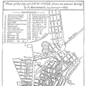
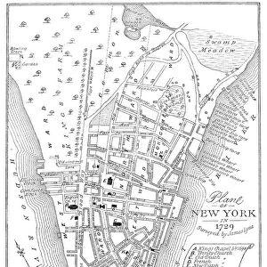
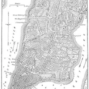
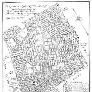
Bernard Ratzers map of New York, 1767, showing lower Manhattan and parts of Brooklyn

![]()
Wall Art and Photo Gifts from Granger
Bernard Ratzers map of New York, 1767, showing lower Manhattan and parts of Brooklyn
NEW YORK: MAP, 1767.
Bernard Ratzers map of New York, 1767, showing lower Manhattan and parts of Brooklyn
Granger holds millions of images spanning more than 25,000 years of world history, from before the Stone Age to the dawn of the Space Age
Media ID 10407910
1767 Bernard Brooklyn Colonial Downtown East River Hudson River Lower Manhattan Manhattan New York City Plan United States
FEATURES IN THESE COLLECTIONS
> Arts
> Landscape paintings
> Waterfall and river artworks
> River artworks
> Granger Art on Demand
> Plans and Diagrams
> North America
> United States of America
> New York
> New York
> Brooklyn
> Related Images
> North America
> United States of America
> New York
> New York
> Manhattan
> Related Images
> North America
> United States of America
> New York
> New York
> Maps
EDITORS COMMENTS
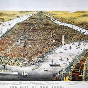
This print showcases Bernard Ratzer's iconic map of New York from 1767, providing a fascinating glimpse into the city's colonial past. With its intricate details and historical significance, this map offers a unique perspective on lower Manhattan and parts of Brooklyn during that era. As one gazes upon it, they are transported back in time to witness the birth of America's most vibrant metropolis. The meticulously hand-drawn streets, buildings, and waterways depicted on this map serve as a testament to Ratzer's skill as an artist and cartographer. From the bustling neighborhoods of downtown Manhattan to the serene shores along the East River and Hudson River, every inch of this masterpiece tells a story about New York City's evolution. As we examine Ratzer's creation closely, we can't help but marvel at how much has changed over centuries while also recognizing certain landmarks that still stand today. This visual journey through time reminds us of our connection to those who came before us and their contributions in shaping the city we know today. Granger Art on Demand presents this extraordinary piece from their Carousel Collection with utmost respect for its historical value. It serves as a reminder not only of New York City's rich heritage but also of the importance of preserving such artifacts for future generations.
MADE IN THE USA
Safe Shipping with 30 Day Money Back Guarantee
FREE PERSONALISATION*
We are proud to offer a range of customisation features including Personalised Captions, Color Filters and Picture Zoom Tools
FREE COLORIZATION SERVICE
You can choose advanced AI Colorization for this picture at no extra charge!
SECURE PAYMENTS
We happily accept a wide range of payment options so you can pay for the things you need in the way that is most convenient for you
* Options may vary by product and licensing agreement. Zoomed Pictures can be adjusted in the Cart.