Home > Animals > Mammals > Pitheciidae > Monachus
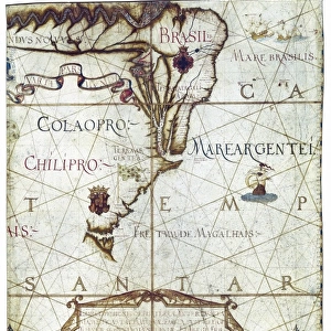
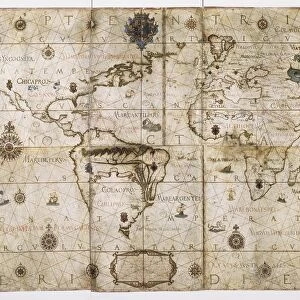
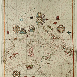
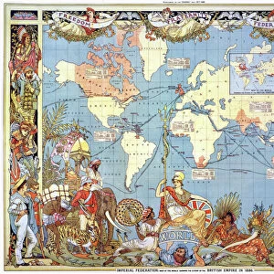
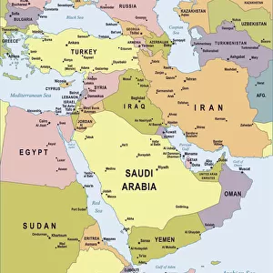
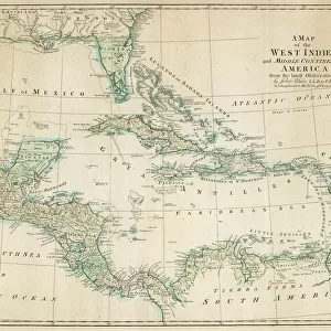
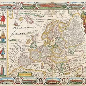
WORLD MAP, 1529. The Western Hemisphere in the world map by Franciscus Monachus

![]()
Wall Art and Photo Gifts from Granger
WORLD MAP, 1529. The Western Hemisphere in the world map by Franciscus Monachus
WORLD MAP, 1529. The Western Hemisphere in the world map by Franciscus Monachus, from De orbis situ, Antwerp, 1529. North America is misrepresented as an extension of Asia
Granger holds millions of images spanning more than 25,000 years of world history, from before the Stone Age to the dawn of the Space Age
Media ID 6617093
1529 Age Of Discovery Amazon River Antarctica Asia Atlantic Ocean Caribbean Caribbean Sea Continent Flemish Globe Gulf Of Mexico Latin Pacific Ocean South America Western Hemisphere Wood Cut World Archipelago Franciscus Monachus Terra Australis
FEATURES IN THESE COLLECTIONS
> Animals
> Mammals
> Cricetidae
> Australis
> Animals
> Mammals
> Delphinidae
> Australis
> Animals
> Mammals
> Molossidae
> Australis
> Animals
> Mammals
> Pitheciidae
> Monachus
> Arts
> Landscape paintings
> Waterfall and river artworks
> River artworks
> Asia
> Related Images
> Granger Art on Demand
> Maps
> Maps and Charts
> World
> North America
> Mexico
> Maps
> South America
> Related Images
EDITORS COMMENTS
This print showcases the "WORLD MAP, 1529" by Franciscus Monachus, a significant piece from the Renaissance era. The Western Hemisphere takes center stage in this woodcut map, extracted from Monachus' renowned work "De orbis situ". However, it is important to note that North America is inaccurately depicted as an extension of Asia. The intricate details and Latin text on this map transport us back to the Age of Discovery when explorers embarked on daring voyages across uncharted territories. The Flemish influence can be observed in the artistry and precision with which each continent, archipelago, and body of water is illustrated. As we delve into this historical masterpiece, our eyes are drawn to notable features such as the vast Atlantic Ocean connecting Europe and Africa with the Americas. We also catch glimpses of familiar landmarks like the Caribbean Sea and Gulf of Mexico. Beyond its geographical accuracy or lack thereof lies a deeper narrative about humanity's thirst for knowledge during this transformative period. This print serves as a reminder that even though some representations may not align with modern understanding, they offer valuable insights into how our perception of the world has evolved over time. "The WORLD MAP, 1529" invites us to explore not only physical landscapes but also cultural exchanges between continents. It sparks curiosity about ancient civilizations thriving in South America along rivers like the Amazon River while hinting at Terra Australis Incognita (unknown southern land) yet to be discovered. Immerse
MADE IN THE USA
Safe Shipping with 30 Day Money Back Guarantee
FREE PERSONALISATION*
We are proud to offer a range of customisation features including Personalised Captions, Color Filters and Picture Zoom Tools
SECURE PAYMENTS
We happily accept a wide range of payment options so you can pay for the things you need in the way that is most convenient for you
* Options may vary by product and licensing agreement. Zoomed Pictures can be adjusted in the Cart.