Home > Maps and Charts > Americas
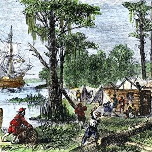
VIRGINIA: MAP, 1738. Map of colonial Virginia. Line engraving after a drawing of 1738

![]()
Wall Art and Photo Gifts from Granger
VIRGINIA: MAP, 1738. Map of colonial Virginia. Line engraving after a drawing of 1738
VIRGINIA: MAP, 1738.
Map of colonial Virginia. Line engraving after a drawing of 1738
Granger holds millions of images spanning more than 25,000 years of world history, from before the Stone Age to the dawn of the Space Age
Media ID 12319783
1738 Colonial Commonwealth United States Virginia Southeast
FEATURES IN THESE COLLECTIONS
> Granger Art on Demand
> Maps
> Maps and Charts
> Early Maps
EDITORS COMMENTS
This print takes us back to the year 1738, offering a glimpse into the colonial era of Virginia. The intricate map showcases the vastness and beauty of this southeastern state in the United States. Created through line engraving after a drawing from that very same year, it is evident that great care and precision were put into capturing every detail. As we study this historical artifact, we are transported to a time when America was still in its infancy. The map reveals the early layout of settlements, rivers, and natural features that shaped Virginia's landscape during this period. It serves as a testament to the pioneering spirit of those who ventured into these uncharted territories. The Granger Collection has masterfully preserved this piece of history for our appreciation today. Its inclusion in their Carousel Collection highlights its significance among other remarkable works of art. With each glance at this print, one can't help but feel connected to Virginia's rich past as a colonial commonwealth. It sparks curiosity about how life must have been like for those who called this land home centuries ago. Whether you are an American history enthusiast or simply appreciate fine craftsmanship, "VIRGINIA: MAP, 1738" is sure to captivate your imagination and transport you on an unforgettable journey through time.
MADE IN THE USA
Safe Shipping with 30 Day Money Back Guarantee
FREE PERSONALISATION*
We are proud to offer a range of customisation features including Personalised Captions, Color Filters and Picture Zoom Tools
SECURE PAYMENTS
We happily accept a wide range of payment options so you can pay for the things you need in the way that is most convenient for you
* Options may vary by product and licensing agreement. Zoomed Pictures can be adjusted in the Cart.