Home > Arts > Landscape paintings > Waterfall and river artworks > River artworks
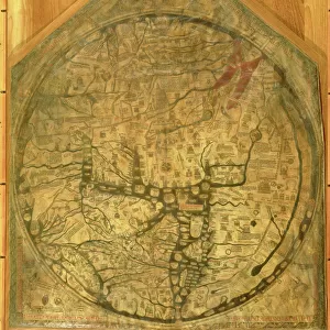
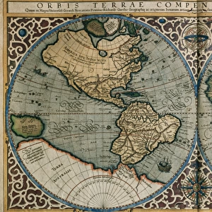
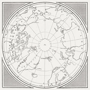
PTOLEMAIC WORLD MAP, 1493. Ptolemaic world map, including depictions of Noahs sons

![]()
Wall Art and Photo Gifts from Granger
PTOLEMAIC WORLD MAP, 1493. Ptolemaic world map, including depictions of Noahs sons
PTOLEMAIC WORLD MAP, 1493.
Ptolemaic world map, including depictions of Noahs sons, Japhet, Shem and Ham, progenitors of the human race in Judeo-Christian tradition. Woodcut from the Nuremberg Chronicle, 1493
Granger holds millions of images spanning more than 25,000 years of world history, from before the Stone Age to the dawn of the Space Age
Media ID 12321082
1493 Christianity Claudius Cosmology Genesis Hartman Hartmann Judaism Mappa Mundi Monster Noah Nuremberg Chronicle Personification Ptolemaic Ptolemy Schedel Wind World Ancestor Japheth Shem
FEATURES IN THESE COLLECTIONS
> Arts
> Landscape paintings
> Waterfall and river artworks
> River artworks
> Granger Art on Demand
> Maps
> Maps and Charts
> World
EDITORS COMMENTS
This print showcases the Ptolemaic World Map from 1493, a remarkable artifact that offers a glimpse into medieval cosmology and religious beliefs. The map, derived from the works of Claudius Ptolemy, not only depicts geographical features but also incorporates fascinating personifications and symbols. One notable aspect of this map is the inclusion of Noah's sons - Japhet, Shem, and Ham - who are considered progenitors of the human race in Judeo-Christian tradition. Their presence highlights the influence of Christianity on medieval cartography as well as its connection to Genesis and biblical narratives. Crafted with intricate woodcut techniques by Hartmann Schedel for the Nuremberg Chronicle, this piece exemplifies Renaissance artistry combined with German craftsmanship. The attention to detail is evident in every element: from winding rivers to mythical creatures lurking within uncharted territories. As we explore this historical masterpiece, we are transported back in time to an era where maps were not just tools for navigation but also representations of cultural beliefs and worldviews. It serves as a reminder that our understanding of geography has evolved over centuries while remaining intertwined with religion and mythology. This print invites us to appreciate both the artistic beauty and intellectual significance behind ancient cartography. Whether you're an enthusiast or simply captivated by history's tapestry, this image provides a window into humanity's quest for knowledge about our vast world.
MADE IN THE USA
Safe Shipping with 30 Day Money Back Guarantee
FREE PERSONALISATION*
We are proud to offer a range of customisation features including Personalised Captions, Color Filters and Picture Zoom Tools
SECURE PAYMENTS
We happily accept a wide range of payment options so you can pay for the things you need in the way that is most convenient for you
* Options may vary by product and licensing agreement. Zoomed Pictures can be adjusted in the Cart.