Home > Arts > Landscape paintings > Waterfall and river artworks > River artworks
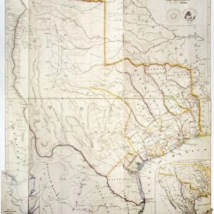
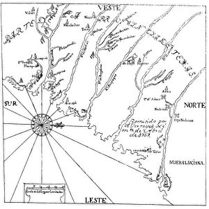
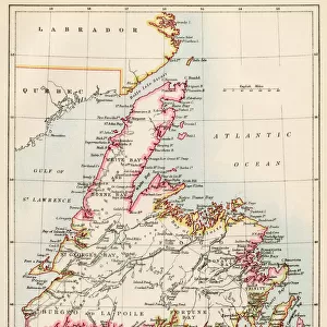
MAP: UNITED STATES, 1849. A General Map of the United States with the contiguous

![]()
Wall Art and Photo Gifts from Granger
MAP: UNITED STATES, 1849. A General Map of the United States with the contiguous
MAP: UNITED STATES, 1849.
A General Map of the United States with the contiguous British & Mexican Possessions: engraved map published, 1849, by Samuel A. Mitchell at Philadelphia
Granger holds millions of images spanning more than 25,000 years of world history, from before the Stone Age to the dawn of the Space Age
Media ID 12321050
1849 Canada Latin America Mesoamerica Mexico United States
FEATURES IN THESE COLLECTIONS
> Arts
> Landscape paintings
> Waterfall and river artworks
> River artworks
> Granger Art on Demand
> Maps
> North America
> Canada
> Maps
> North America
> Mexico
> Maps
EDITORS COMMENTS
This print showcases a historical treasure, the "MAP: UNITED STATES, 1849". It is a remarkable representation of the United States during that era, meticulously engraved by Samuel A. Mitchell and published in Philadelphia in 1849. The map encompasses not only the contiguous states but also provides insight into the British and Mexican possessions at that time. As we delve into this piece of art, it transports us back to an important period in American history. With its intricate details and precise cartography, this map offers a glimpse into the vastness of America's expansion during the mid-19th century. From coast to coast, it captures every state with utmost accuracy. Beyond just depicting borders and territories, this map serves as a visual testament to America's influence on its neighboring regions. It highlights Canada to the north and various Latin American countries to the south, including Mexico and Mesoamerica. The inclusion of major rivers further enhances our understanding of how these waterways played crucial roles in shaping transportation routes and trade networks across different parts of America. Through this print from Granger Art on Demand, viewers can appreciate both the artistic beauty and historical significance encapsulated within this exquisite engraving. Whether you are an avid historian or simply intrigued by maps' ability to tell stories about our past, "MAP: UNITED STATES, 1849" is sure to captivate your imagination for hours on end.
MADE IN THE USA
Safe Shipping with 30 Day Money Back Guarantee
FREE PERSONALISATION*
We are proud to offer a range of customisation features including Personalised Captions, Color Filters and Picture Zoom Tools
SECURE PAYMENTS
We happily accept a wide range of payment options so you can pay for the things you need in the way that is most convenient for you
* Options may vary by product and licensing agreement. Zoomed Pictures can be adjusted in the Cart.