Home > Europe > United Kingdom > England > Maps
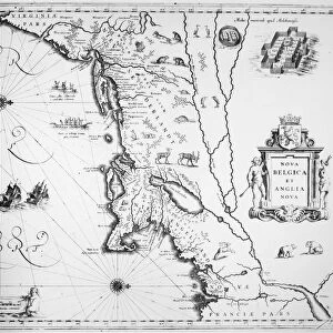
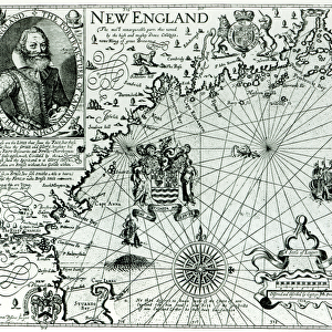
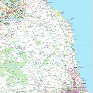
MAP OF NEW ENGLAND, 1732. Henry Popples map of New England, published in London

![]()
Wall Art and Photo Gifts from Granger
MAP OF NEW ENGLAND, 1732. Henry Popples map of New England, published in London
MAP OF NEW ENGLAND, 1732.
Henry Popples map of New England, published in London, England, in 1732
Granger holds millions of images spanning more than 25,000 years of world history, from before the Stone Age to the dawn of the Space Age
Media ID 12321056
1732 Atlantic Ocean Coast Colonial Henri New England Seashore United States Popple
FEATURES IN THESE COLLECTIONS
> Arts
> Landscape paintings
> Waterfall and river artworks
> River artworks
> Europe
> United Kingdom
> England
> London
> Related Images
> Europe
> United Kingdom
> England
> Maps
> Europe
> United Kingdom
> England
> Rivers
> Granger Art on Demand
> Maps
> Maps and Charts
> Early Maps
EDITORS COMMENTS
This print showcases the historic "Map of New England, 1732" by Henry Popple. Published in London, England during the early colonial era, this map offers a fascinating glimpse into the North American continent's past. With intricate details and precision, Popple's map depicts the vast expanse of New England, stretching from the Atlantic Ocean to its picturesque coastlines. The rivers meander across the landscape like lifelines connecting communities and providing vital transportation routes. As we delve into this piece of cartographic artistry, it becomes evident that Popple was not only an exceptional geographer but also a keen observer of nature. The seashore is beautifully rendered with delicate strokes, capturing both its rugged beauty and untamed allure. This historical artifact serves as a testament to America's rich heritage and its colonial roots. It transports us back in time to an era when exploration and settlement were shaping what would eventually become the United States. Whether you are an avid history enthusiast or simply appreciate fine artistry, this print invites you to immerse yourself in a world where discovery meets artistic brilliance. Hang it proudly on your wall and let it be a conversation starter for all who admire its beauty – reminding us of our collective journey through time.
MADE IN THE USA
Safe Shipping with 30 Day Money Back Guarantee
FREE PERSONALISATION*
We are proud to offer a range of customisation features including Personalised Captions, Color Filters and Picture Zoom Tools
SECURE PAYMENTS
We happily accept a wide range of payment options so you can pay for the things you need in the way that is most convenient for you
* Options may vary by product and licensing agreement. Zoomed Pictures can be adjusted in the Cart.