Home > Arts > Landscape paintings > Waterfall and river artworks > River artworks
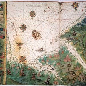
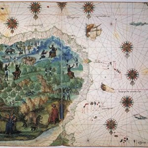
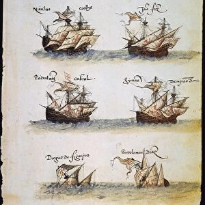
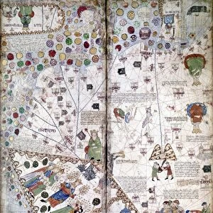
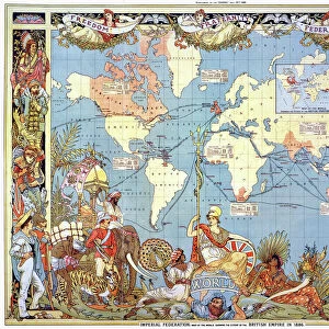
MAP OF THE MOLUCCAS. Also known as Spice Islands, at left, from the Vallard Atlas

![]()
Wall Art and Photo Gifts from Granger
MAP OF THE MOLUCCAS. Also known as Spice Islands, at left, from the Vallard Atlas
MAP OF THE MOLUCCAS. Also known as Spice Islands, at left, from the Vallard Atlas, c1547
Granger holds millions of images spanning more than 25,000 years of world history, from before the Stone Age to the dawn of the Space Age
Media ID 6622335
1547 Indonesian Portolan Chart Spice Islands
FEATURES IN THESE COLLECTIONS
> Arts
> Landscape paintings
> Waterfall and river artworks
> River artworks
> Granger Art on Demand
> Maps
> Maps and Charts
> Related Images
EDITORS COMMENTS
The captivating "MAP OF THE MOLUCCAS" print, also referred to as the Spice Islands, is a remarkable piece from the Vallard Atlas dating back to 1547. This exquisite map showcases the intricate details of this Indonesian archipelago during the Renaissance era. With its rich historical significance and artistic charm, it transports us back in time to an age of exploration and discovery. The map depicts a network of rivers flowing through lush landscapes, highlighting the region's natural beauty. The intricate portolan chart style adds depth and precision to the representation of coastlines and islands. It serves as a testament to the cartographic skills prevalent during that period. Known for their abundance in valuable spices such as nutmeg, cloves, and mace, these islands played a pivotal role in shaping world history. Explorers from around the globe sought after these precious commodities which were highly prized at that time. This Granger Collection print offers viewers an opportunity to delve into this fascinating chapter of human civilization. Its vibrant colors and meticulous detailing make it not only visually appealing but also educational for those interested in geography or history. Whether displayed on a wall or used for research purposes, this MAP OF THE MOLUCCAS print is sure to captivate anyone with an appreciation for artistry intertwined with cultural heritage.
MADE IN THE USA
Safe Shipping with 30 Day Money Back Guarantee
FREE PERSONALISATION*
We are proud to offer a range of customisation features including Personalised Captions, Color Filters and Picture Zoom Tools
SECURE PAYMENTS
We happily accept a wide range of payment options so you can pay for the things you need in the way that is most convenient for you
* Options may vary by product and licensing agreement. Zoomed Pictures can be adjusted in the Cart.